Alpine Loop Back Country Byway
Alpine Loop Back Country Byway | |
|---|---|
| Route information | |
| Maintained by CDOT | |
| Length | 63 mi[1][2] (101 km) |
| Existed | 1989–present |
| Major junctions | |
| West end |  US 550 at Ouray or Silverton US 550 at Ouray or Silverton |
| East end |  SH 149 Lake City SH 149 Lake City |
| Location | |
| Country | United States |
| State | Colorado |
| Counties | Hindale, Ouray, and San Juan |
| Highway system | |
| |


The Alpine Loop Back Country Byway is a rugged 63-mile (101 km) Back Country Byway and Colorado Scenic and Historic Byway located in the high San Juan Mountains of Hindale, Ouray, and San Juan counties, Colorado, USA. The byway connects the mountain towns of Lake City, Ouray, and Silverton. The route ranges in elevation from (a mere) 7,792 feet (2,375 m) in Ouray to 12,800 feet (3,901 m) at Engineer Pass. The byway features high mountain passes, alpine tundra, beautiful mountain meadows, ghost towns, and relics of the silver mining era. While the meadows and tundra are accessible to ordinary passenger vehicles, a high-clearance 4-wheel drive vehicle is required to travel the entire route.
The Silverton Historic District and the Shenandoah-Dives (Mayflower) Mill are National Historic Landmarks. The Alpine Loop connects with the San Juan Skyway Scenic and Historic Byway at Ouray and Silverton.
Route
The Alpine Loop is generally considered to begin and end at Lake City. From there the route commonly followed is west over Cinnamon Pass or Engineer Pass to Animas Forks, and then returning east back to Lake City. The clockwise circuit starting with Cinnamon Pass generally puts the vehicle on the inside "lane" of the mountainous portions with the driver on the outside, providing a better view of the relative position of the vehicle and the outer edge of the road at the top of the drop-off. [3] The counter-clockwise direction is preferable for less powerful 4-wheel drive vehicles that may have a difficult time ascending steep sections on the western portion of Engineer Pass.
Major intersections
| County | Location | mi | km | Destinations | Notes |
|---|---|---|---|---|---|
| Hinsdale | Lake City | 0.00 | 0.00 |  SH 149 north SH 149 north | Zero milepost |
| |  FH 14 FH 14 | ||||
| |  SH 149 south SH 149 south | Becomes FH 30 west | |||
| |  FH 33 FH 33 | ||||
| | FH 33 | ||||
| | Camp Redcloud | ||||
| | Castle Lakes Campground | ||||
| |  FH 36 FH 36 | ||||
| |  FH 35 FH 35 | ||||
| |  FH 12 FH 12 | ||||
| |   FH 5 west FH 5 west | Becomes FH 5 west | |||
| San Juan | |   FH 2 south FH 2 south | Becomes FH 2 north | ||
| |  FH 18 FH 18 | ||||
| |  FH 17 FH 17 | ||||
| | FH 2 west | Becomes an unmarked road | |||
| Hinsdale | |  FH 21 south FH 21 south | Becomes FH 21 north | ||
| |  FH 21 north FH 21 north | Becomes FH 20X east | |||
| |  FH 20 west FH 20 west | Becomes FH 20 east | |||
| |  FH 24 FH 24 | ||||
| |  FH 23 FH 23 | ||||
| | SH 149 | ||||
| 1.000 mi = 1.609 km; 1.000 km = 0.621 mi | |||||
Gallery
-
 Along the road to Engineer pass
 -
 Abandoned building in Animas Forks, on the Alpine Loop
 -
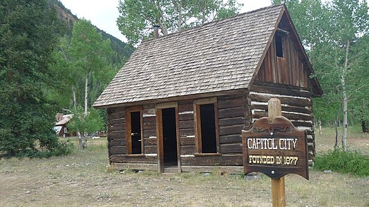 Capitol City ghost town
 -
 California Gulch Road, near Animas Forks
 -
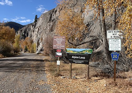 Signs at the start of the road in Lake City
 -
 Colorado blue columbine along the Alpine Loop
 -

-

-
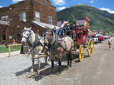 A stagecoach in Silverton


See also
 History portal
 U.S. Roads portal
 Colorado portal
Notes
References
- ^ "Alpine Loop". Colorado Department of Transportation. 2021. Retrieved April 3, 2022.
- ^ "Alpine Loop". America's Scenic Byways. Retrieved April 3, 2022.
- ^ "The Alpine Loop" (PDF). United States Department of the Interior Bureau of Land Management. Archived from the original (PDF) on 11 June 2014. Retrieved 1 February 2015.
External links
Colorado at Wikipedia's sister projects
 Media from Commons
 News from Wikinews
 Quotations from Wikiquote
 Travel information from Wikivoyage
- America's Scenic Byways: Colorado
- Bureau of Land Management Back Country Byways
- BLM Alpine Loop website
- Colorado Department of Transportation
- Colorado Scenic & Historic Byways Commission
- Colorado Scenic & Historic Byways
- Colorado Travel Map
- Colorado Scenic & Historic Byways Commission
- Colorado Tourism Office
- History Colorado
- v
- t
- e
Denver (capital)
- Bibliography
- Index
- Outline
- Climate change
- Colleges
- Coloradans
- Elections
- Federal lands
- Geography
- Government
- Historic places
- History
- Images
- Indian reservations
- Law
- Lists
- Military
- Mountains
- Municipalities
- Museums
- National Forests
- National Parks
- Paleontology
- Prehistoric sites
- Prehistory
- Protected areas
- Railroads
- Rivers
- Slavery
- Statistical areas
- Symbols
- Timeline
- Tourist attractions
- Towns
- Trails
- Transportation
- Wildernesses
- Alamosa
- Arvada
- Aspen
- Aurora
- Black Hawk
- Boulder
- Brighton
- Broomfield
- Brush
- Burlington
- Cañon City
- Castle Pines
- Centennial
- Central City
- Cherry Hills Village
- Colorado Springs
- Commerce City
- Cortez
- Craig
- Cripple Creek
- Dacono
- Delta
- Denver
- Durango
- Edgewater
- Englewood
- Evans
- Federal Heights
- Florence
- Fort Collins
- Fort Lupton
- Fort Morgan
- Fountain
- Fruita
- Glendale
- Glenwood Springs
- Golden
- Grand Junction
- Greeley
- Greenwood Village
- Gunnison
- Holyoke
- Idaho Springs
- La Junta
- Lafayette
- Lakewood
- Lamar
- Las Animas
- Leadville
- Littleton
- Lone Tree
- Longmont
- Louisville
- Loveland
- Manitou Springs
- Monte Vista
- Montrose
- Northglenn
- Ouray
- Pueblo
- Rifle
- Rocky Ford
- Salida
- Sheridan
- Steamboat Springs
- Sterling
- Thornton
- Trinidad
- Victor
- Walsenburg
- Westminster
- Wheat Ridge
- Woodland Park
- Wray
- Yuma
- Adams
- Alamosa
- Arapahoe
- Archuleta
- Baca
- Bent
- Boulder
- Broomfield
- Chaffee
- Cheyenne
- Clear Creek
- Conejos
- Costilla
- Crowley
- Custer
- Delta
- Denver
- Dolores
- Douglas
- Eagle
- El Paso
- Elbert
- Fremont
- Garfield
- Gilpin
- Grand
- Gunnison
- Hinsdale
- Huerfano
- Jackson
- Jefferson
- Kiowa
- Kit Carson
- La Plata
- Lake
- Larimer
- Las Animas
- Lincoln
- Logan
- Mesa
- Mineral
- Moffat
- Montezuma
- Montrose
- Morgan
- Otero
- Ouray
- Park
- Phillips
- Pitkin
- Prowers
- Pueblo
- Rio Blanco
- Rio Grande
- Routt
- Saguache
- San Juan
- San Miguel
- Sedgwick
- Summit
- Teller
- Washington
- Weld
- Yuma
- Central Colorado
- Eastern Plains
- Colorado Mineral Belt
- Colorado Piedmont
- Colorado Plateau
- Colorado Western Slope
- Denver Metropolitan Area
- Four Corners Region
- Front Range Urban Corridor
- High Plains
- North Central Colorado Urban Area
- Northwestern Colorado
- San Luis Valley
- South-Central Colorado
- South Central Colorado Urban Area
- Southern Rocky Mountains
- Southwest Colorado
 Colorado portal
| Authority control databases |
|
|---|
37°58′32″N 107°35′04″W / 37.9756°N 107.5845°W / 37.9756; -107.5845 (Engineer Pass, Colorado, USA)


