Beaver Meadows Visitor Center
United States historic place
Rocky Mountain National Park Administration Building | |
U.S. National Historic Landmark | |
U.S. Historic district Contributing property | |
 | |
40°21′58″N 105°33′39″W / 40.36611°N 105.56083°W / 40.36611; -105.56083 | |
| Area | less than one acre |
|---|---|
| Architect | Taliesin Associated Architects |
| Architectural style | Park Service Modern |
| Part of | Rocky Mountain National Park Utility Area Historic District (ID82001717) |
| MPS | Rocky Mountain National Park MRA |
| NRHP reference No. | 01000069 |
| Significant dates | |
| Added to NRHP | January 3, 2001[1] |
| Designated NHL | January 3, 2001[2] |
| Designated CP | March 18, 1982 |
Beaver Meadows Visitor Center, also known as Rocky Mountain National Park Administration Building, is the park headquarters and principal visitors center of Rocky Mountain National Park in central northern Colorado. Completed in 1967, it was designed by Taliesin Associated Architects, and was one of the most significant commissions for that firm in the years immediately following the death of founder Frank Lloyd Wright.[3] It was also one of the last major projects completed under the Park Service Mission 66 project. It was declared a National Historic Landmark in 2001.[2][4]
Description and history
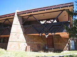
The Beaver Meadows Visitor Center is located on the south side of United States Route 36 near the principal eastern entrance to Rocky Mountain National Park. As seen from visitor (north) side, the building presents as a single-story structure, but is actually two stories owing to the sloping terrain on which it is built. It is a rectangular structure, built with a steel frame and cast concrete panels, into which slabs of sandstone have been embedded. The upper level framing has Cor-Ten steel set in a zigzag pattern inspired by Native American artworks. The building's eastern end is devoted to visitor facilities, including a lobby, amphitheater, and shop, with an inside observation area and outside balcony providing views of the Rocky Mountains. The western end houses park offices in a modular design with movable partitions.[4]
Rocky Mountain National Park was founded in 1915. As part of the Park Service's Mission 66 program to revitalize the nation's park system, the Park Service hired the firm of Taliesin Associated Architects in 1964 to design a new visitors center for the park. Construction began in 1965 and was completed in 1967. The building has been relatively little altered since then: the shop occupies a former lobby area that included benches and a fireplace, and changes in equipment for the theater necessitated the closure of a balcony entrance.[4]
Map

See also
- Rocky Mountain National Park Utility Area Historic District
- National Register of Historic Places listings in Larimer County, Colorado
- List of National Historic Landmarks in Colorado
References
- ^ "National Register Information System". National Register of Historic Places. National Park Service. January 23, 2007.
- ^ a b "Rocky Mountain National Park Administration Building". National Historic Landmark summary listing. National Park Service. Archived from the original on February 6, 2009. Retrieved October 15, 2007.
- ^ National Historic Landmark summary Archived 2009-02-06 at the Wayback Machine National Historic Landmarks Program, accessed 31 October 2007
- ^ a b c Sarah Allaback and Ethan Carr (September 1, 2000) National Register of Historic Places Inventory-Nomination: Rocky Mountain National Park Administration Building / Headquarters Building / Beaver Meadows Visitor Center, National Park Service and Accompanying 7 photos, exterior and interior, from 1982 and 1999.
External links
Wikimedia Commons has media related to Beaver Meadows Visitor Center.
- Rocky Mountain National Park Official Site
- Beaver Meadows Visitor Center Information
- Beaver Meadows Visitor Center, described in Fodors guidebook
- v
- t
- e
- Alpine Visitor Center
- Alpine Tundra Research
- Beaver Meadows Visitor Center
- Agnes Vaille Shelter
- Dutchtown (ghost town)
- Fall River Pass
- Horseshoe Park
- Kawuneeche Valley
- Lulu City (ghost town)
- Lumpy Ridge
- Middle Park
- Milner Pass (Continental Divide)
- Moraine Park Museum and Amphitheater
- Petit Grepon (spire)
- Tuxedo Park
- Upper Beaver Meadows
- Wild Basin
| Peaks |
|
|---|---|
| Hiking trails and technical climbs |
|
| Glaciers |
|
| Bodies of water |
|
- History of Rocky Mountain National Park
- NRHP listings in RMNP
- NRHP in Rocky Mountain NP template
- Districts or areas
& camping
- Park Roads
- Highways
- Denver International Airport
- Denver Union Station
- RTD
municipalities
geography
information
- Rocky Mountain National Park Category
- Colorado Portal
| |
|---|---|
| Topics | |
| Lists by state |
|
| Lists by insular areas | |
| Lists by associated state | |
| Other areas | |
| Related | |
| |


