Ascarat
Commune in Nouvelle-Aquitaine, France
Ascarat Azkarate | ||
|---|---|---|
Commune | ||
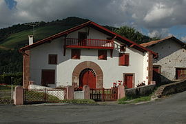 Traditional Farmhouse in Ascarat | ||
 Coat of arms | ||
Location of Ascarat  | ||
(2020–2026) Philippe Etchenique[1] | | |
| Area 1 | 5.82 km2 (2.25 sq mi) | |
| Population (2021)[2] | 339 | |
| • Density | 58/km2 (150/sq mi) | |
| Time zone | UTC+01:00 (CET) | |
| • Summer (DST) | UTC+02:00 (CEST) | |
| INSEE/Postal code | 64066 /64220 | |
| Elevation | 120–446 m (394–1,463 ft) (avg. 161 m or 528 ft) | |
| 1 French Land Register data, which excludes lakes, ponds, glaciers > 1 km2 (0.386 sq mi or 247 acres) and river estuaries. | ||
Ascarat (French pronunciation: [askaʁat]; Basque: Azkarate)[3] is a commune in the Pyrénées-Atlantiques department in the Nouvelle-Aquitaine region of south-western France.
The inhabitants are known as Azkaratear.[4][5]
Geography

Ascarat is located in the former province of Lower Navarre in the Aldudes Valley immediately north-west of Saint-Jean-Pied-de-Port. Access to the commune is by the D918 road from Saint-Jean-Pied-de-Port which passes through the length of the commune on the eastern side and continues to Louhossoa. The D15 road goes north-west from Saint-Jean-Pied-de-Port through the southern part of the commune continuing to Irouléguy. Access to the village is by country roads - Garategana from the D15 and Learraa from the D918. There are substantial forests in the commune however about 70% of the land area is farmland.[6]
The Nive river forms the eastern border of the commune as it flows north to join the Adour at Bayonne. Three streams flow into the Nive in the commune: the Nive d'Arnéguy, the Nive de Béhérobie, the Berroko erreka, and the Pagolako erreka.[6]
Places and hamlets
- Apelchénéa
- Arbelarréa
- Arrécharborda
- Béhérekoetchéa
- Bentaberria
- Beskinaénéa
- Bidartéa
- Bordia
- Burugorriénéa
- Caracotchéa
- Choko Ona
- Errékaldéa
- Fargas (château)
- Ferrandoénéa
- Garatégaïna
- Haranbiako Borda
- Harguinaénéa
- Harguinchuria
- Hirureta
- Indartéa
- Iputchaénéa
- Ithurraldéa
- Ithurricheta
- Jauberria
- Pontoussénéa
- Puchulua
- La Solitude
- Tofinaenea
- Uhaldéa
Neighbouring communes and villages[6] | |
|---|---|


Toponymy
The name Ascarat appears in the forms:
- Ascarat (1106[8]),
- Escarat (13th century[8]),
- Azcarat (1350[8]),
- Atzcarat (1366[8]),
- Azquarat (1413[8]),
- Axcarat (1513,[9] Titles of Pamplona[10]),
- Axcarate (1621,[9] Martin Biscay[11]), and
- Sanctus Julianus d'Ascarat (1763,[9] Collations of the Diocese of Bayonne[12]).
Jean-Baptiste Orpustan indicated that the name is composed of aitz ("rock") and garate ("high place"), giving "a height of rocks".[8]
Chubitoa was a hamlet in Ascarat and Anhaux, mentioned in 1863[13]
Jauréguy was a fief, vassal of the Kingdom of Navarre, cited in the 1863 dictionary[14] as was Larragoyen.[15]
The commune name in basque is Azkarate.[3][5]
History
The parish was mentioned in 1256 and was "ravaged by soldiers" in 1396.[16]
In 1391 Saint-Étienne-de-Baïgorry included the modern communes of Anhaux, Ascarat, Irouléguy, and Lasse.[17]
Heraldry
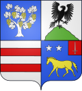 | Blazon: Quarterly, at 1 Azure, a vine stalk leaved in Argent, fruited in Or; at 2 Argent an eagle rising of Sable on a mount of Vert; at 3 Argent with 2 fesses of Gules; at 4 Azure with a horse gai passant of Or surmounted by two mullets of Argent posed in fesse, a canton sinister of Gules charged with a sword of Argent.
|
Administration
This list is incomplete; you can help by adding missing items. (April 2021) |
List of Successive Mayors[18]
| From | To | Name | Party | Position |
|---|---|---|---|---|
| 1995 | 2020 | Jean-Michel Galant | AB | General Councillor |
| 2020 | 2026 | Philippe Etchenique |
Inter-communality
The commune is part of nine inter-communal structures:[19]
- the Communauté d'agglomération du Pays Basque;
- the SIVOS of Garazi;
- the SIVU Hiruen Artean;
- the AEP association of Anhice;
- the Energy association of Pyrénées-Atlantiques;
- the inter-communal association for sanitation of Ur Garbi;
- the inter-communal association for the management and development of the abattoir at Saint-Jean-Pied-de-Port;
- the joint association for the Drainage basin of the Nive;
- the association to support Basque culture.
Demography
In 2017 the commune had 321 inhabitants.
|
| ||||||||||||||||||||||||||||||||||||||||||||||||||||||||||||||||||||||||||||||||||||||||||||||||||||||||||||||||||
| |||||||||||||||||||||||||||||||||||||||||||||||||||||||||||||||||||||||||||||||||||||||||||||||||||||||||||||||||||
| Source: EHESS[20] and INSEE[21] | |||||||||||||||||||||||||||||||||||||||||||||||||||||||||||||||||||||||||||||||||||||||||||||||||||||||||||||||||||
Economy
The commune is part of the production zone of the Appellation d'origine contrôlée (AOC) of Irouléguy and also of the AOC zone of Ossau-iraty.
Economic activity is mainly agricultural.
Culture and heritage

Civil heritage
There are several houses and farms in the commune which are registered as historical monuments. These are:
- Uhaldea House (18th century)
 [22]
[22] - Harizpea Farm (1587)[23]
- Chateau de Vergues (or Chateau de Fargas) (18th century)[24]
- Houses and Farms (17th-19th centuries)[25]
Religious heritage
The Church of Saint-Julien-d'Antioche![]() is of medieval origin was heavily rebuilt in the 18th and 19th century.[26]
is of medieval origin was heavily rebuilt in the 18th and 19th century.[26]
Notable people linked to the commune
- Pierre Narbaitz, born in 1910 at Ascarat and died in 1984 at Cambo-les-Bains, was a historian, writer, and a basque French academic of the Basque and French languages.
See also
References
- ^ "Répertoire national des élus: les maires". data.gouv.fr, Plateforme ouverte des données publiques françaises (in French). 2 December 2020.
- ^ "Populations légales 2021". The National Institute of Statistics and Economic Studies. 28 December 2023.
- ^ a b AZKARATE, Auñamendi Eusko Entziklopedia (in Spanish)
- ^ Brigitte Jobbé-Duval, Dictionary of place names - Pyrénées-Atlantiques, 2009, Archives and Culture, ISBN 978-2-35077-151-9 (in French)
- ^ a b Euskaltzaindia - Academy of the Basque language (Basque)
- ^ a b c Google Maps
- ^ Géoportail, IGN (in French)
- ^ a b c d e f Jean-Baptiste Orpustan, New Basque Toponymy, Presses universitaires de Bordeaux, 2006, ISBN 2 86781 396 4 (in French)
- ^ a b c Topographic Dictionary of the Department of Basses-Pyrenees, Paul Raymond, Imprimerie nationale, 1863, Digitised from Lyon Public Library 15 June 2011, p. 15 (in French)
- ^ Titles published by don José Yanguas y Miranda (in French)
- ^ Derecho de naturaleza que la merindad de San-Juan-del-pie-del-puerto, una de las seys de Navarra, tiene en Castilla - 1622 petit in-4° (in Spanish)
- ^ Manuscripts from the 17th and 18th centuries - Departmental Archives of Pyrénées-Atlantiques (in French)
- ^ Topographic Dictionary of the Department of Basses-Pyrenees, p. 50 (in French)
- ^ Topographic Dictionary of the Department of Basses-Pyrenees, p. 85 (in French)
- ^ Topographic Dictionary of the Department of Basses-Pyrenees, p. 94 (in French)
- ^ Ministry of Culture, Mérimée IA64000420 Presentation of the commune of Ascarat (in French)
- ^ Ministry of Culture, Mérimée IA64000425 Presentation of the commune of Saint-Étienne-de-Baïgorry (in French)
- ^ List of Mayors of France (in French)
- ^ Intercommunality of Pyrénées-Atlantiques Archived 2014-05-12 at the Wayback Machine, Cellule informatique préfecture 64, consulted on 2 March 2012 (in French)
- ^ Des villages de Cassini aux communes d'aujourd'hui: Commune data sheet Ascarat, EHESS (in French).
- ^ Population en historique depuis 1968, INSEE
- ^ Ministry of Culture, Mérimée IA64000459 Uhaldea House (in French)
- ^ Ministry of Culture, Mérimée IA64000416 Harizpea Farm (in French)
- ^ Ministry of Culture, Mérimée IA64000415 Chateau de Vergues (in French)
- ^ Ministry of Culture, Mérimée IA64000486 Houses and Farms (in French)
- ^ Ministry of Culture, Mérimée IA64000414 Church of Saint-Julien-d'Antioche (in French)
External links
- Ascarat on Géoportail, National Geographic Institute (IGN) website (in French)
- Azcarat on the 1750 Cassini Map
Wikimedia Commons has media related to Ascarat.
- v
- t
- e
- Ahaxe-Alciette-Bascassan
- Ayherre
- Ainhice-Mongelos
- Aincille
- Aïcirits-Camou-Suhast
- Came
- Aldudes
- Amendeuix-Oneix
- Amorots-Succos
- Anhaux
- Arbérats-Sillègue
- Arbouet-Sussaute
- Arhansus
- Armendarits
- Arnéguy
- Saint-Martin-d'Arrossa
- Arraute-Charritte
- Ascarat
- Saint-Étienne-de-Baïgorry
- Banca
- La Bastide-Clairence
- Béhasque-Lapiste
- Béguios
- Béhorléguy
- Bidache
- Bidarray
- Beyrie-sur-Joyeuse
- Bunus
- Bergouey-Viellenave
- Bustince-Iriberry
- Saint-Just-Ibarre
- Saint-Martin-d'Arberoue
- Saint-Palais
- Saint-Jean-le-Vieux
- Saint-Jean-Pied-de-Port
- Saint-Esteben
- Bussunarits-Sarrasquette
- Saint-Michel
- Arancou
- Estérençuby
- Gabat
- Gamarthe
- Garris
- Hélette
- Hosta
- Jaxu
- Ibarrolle
- Iholdy
- Ilharre
- Irissarry
- Irouléguy
- Isturits
- Ispoure
- Ostabat-Asme
- Juxue
- Labets-Biscay
- Lacarre
- Lantabat
- Larribar-Sorhapuru
- Larceveau-Arros-Cibits
- Lasse
- Lecumberry
- Luxe-Sumberraute
- Masparraute
- Méharin
- Mendive
- Orègue
- Ossès
- Orsanco
- Pagolle
- Sames
- Uhart-Cize
- Uhart-Mixe
- Urepel
- Çaro


Authority control databases | |
|---|---|
| International |
|
| National |
|


