Louhossoa
Commune in Nouvelle-Aquitaine, France
Louhossoa Luhuso | ||
|---|---|---|
Commune | ||
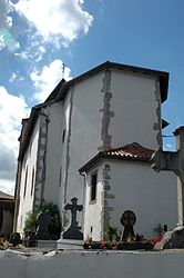 The church of Louhossoa | ||
 Coat of arms | ||
Location of Louhossoa  | ||
(2020–2026) Jean-Pierre Harriet[1] | | |
| Area 1 | 7.38 km2 (2.85 sq mi) | |
| Population (2021)[2] | 856 | |
| • Density | 120/km2 (300/sq mi) | |
| Time zone | UTC+01:00 (CET) | |
| • Summer (DST) | UTC+02:00 (CEST) | |
| INSEE/Postal code | 64350 /64250 | |
| Elevation | 71–369 m (233–1,211 ft) (avg. 100 m or 330 ft) | |
| 1 French Land Register data, which excludes lakes, ponds, glaciers > 1 km2 (0.386 sq mi or 247 acres) and river estuaries. | ||
Louhossoa (French pronunciation: [lu.ɔsɔa]; Basque: Luhuso)[3] is a small village and a commune in the Pyrénées-Atlantiques department in south-western France. It is part of the traditional Basque province of Labourd.[3]
See also
References
- ^ "Répertoire national des élus: les maires". data.gouv.fr, Plateforme ouverte des données publiques françaises (in French). 2 December 2020.
- ^ "Populations légales 2021". The National Institute of Statistics and Economic Studies. 28 December 2023.
- ^ a b LUHUSO, Auñamendi Eusko Entziklopedia (in Spanish)
Wikimedia Commons has media related to Louhossoa.
- v
- t
- e
Municipalities in Labourd (Lapurdi)
- Ahetze
- Ainhoa
- Anglet (Angelu / Anglet)
- Arbonne (Arbona)
- Arcangues (Arrangoitze)
- Ascain (Azkaine)
- Bardos (Bardoze)
- Bassussarry (Basusarri)
- Bayonne (Baiona)
- Biarritz (Miarritze / Biàrritz)
- Bidart (Bidarte)
- Biriatou (Biriatu)
- Bonloc (Lekuine)
- Boucau (Bokale / Bocau)
- Briscous (Beskoitze)
- Cambo-les-Bains (Kanbo)
- Ciboure (Ziburu)
- Espelette (Ezpeleta)
- Guéthary (Getaria)
- Guiche (Gixune / Guishe)
- Halsou (Haltsu)
- Hasparren (Hazparne)
- Hendaye (Hendaia)
- Itxassou (Itsasu)
- Jatxou (Jatsu)
- Lahonce (Lehuntze)
- Larressore (Larresoro)
- Louhossoa (Luhuso)
- Macaye (Makea)
- Mendionde (Lekorne)
- Mouguerre (Mugerre)
- Saint-Jean-de-Luz (Donibane Lohizune)
- Saint-Pée-sur-Nivelle (Senpere)
- Saint-Pierre-d'Irube (Hiriburu)
- Sare (Sara)
- Souraïde (Zuraide)
- Urcuit (Urketa)
- Urrugne (Urruña)
- Urt (Ahurti)
- Ustaritz (Uztaritze)
- Villefranque (Milafranga)


Authority control databases | |
|---|---|
| International |
|
| National |
|
 | This Pyrénées-Atlantiques geographical article is a stub. You can help Wikipedia by expanding it. |
- v
- t
- e


