Củ Chi district
You can help expand this article with text translated from the corresponding article in Vietnamese. (June 2013) Click [show] for important translation instructions.
- View a machine-translated version of the Vietnamese article.
- Machine translation, like DeepL or Google Translate, is a useful starting point for translations, but translators must revise errors as necessary and confirm that the translation is accurate, rather than simply copy-pasting machine-translated text into the English Wikipedia.
- Do not translate text that appears unreliable or low-quality. If possible, verify the text with references provided in the foreign-language article.
- You must provide copyright attribution in the edit summary accompanying your translation by providing an interlanguage link to the source of your translation. A model attribution edit summary is
Content in this edit is translated from the existing Vietnamese Wikipedia article at [[:vi:Củ Chi]]; see its history for attribution. - You may also add the template
{{Translated|vi|Củ Chi}}to the talk page. - For more guidance, see Wikipedia:Translation.
District in Ho Chi Minh City, Vietnam
Củ Chi district Huyện Củ Chi | |
|---|---|
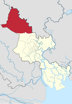 Position in metropolitan area of HCMC | |
| 11°02′17″N 106°30′20″E / 11.03806°N 106.50556°E / 11.03806; 106.50556 | |
| Country |  Vietnam Vietnam |
| Centrally governed city | Ho Chi Minh City |
| Seat | Quarter 7, Củ Chi Town |
| Divisions | 1 township, 20 communes |
| Area | |
| • Total | 435 km2 (168 sq mi) |
| Population (2018) | |
| • Total | 403,038 |
| • Density | 930/km2 (2,400/sq mi) |
| Demographics | |
| • Main ethnic groups | predominantly Kinh |
| Time zone | UTC+07 (ICT) |
| Website | cuchi.hochiminhcity.gov.vn |
Củ Chi is a rural district of Ho Chi Minh City, Vietnam.
Etymology
The Vietnamese word Củ Chi ([kʊw˨˩˦ cɪj˧˧], koo-kee) is derived from the old Mon-Khmer words Tonle Sre (ទន្លេស្រែ, "river of rice-field") or Sre (ស្រែ "rice field").[citation needed]
History
During the Vietnam War from 1967, Củ Chi Base Camp served as base for the 269th Aviation Battalion of the United States Army.
It is famous for its Củ Chi tunnels, which were constructed during the Vietnam War, and served as headquarters for the Viet Cong. Today, the district has many industrial zones.
As of 2010[update], the district had a population of 355,822. It covers an area of 435 km².[1] The district capital lies at Củ Chi Town.
Administration
The district consists of 1 town, Củ Chi Town (also the district capital), and 20 communes:
- Communes:
|
|
See also
References
- ^ "HCMC's Population and population density in 2010 by district". HCMC Office of Statistics. Archived from the original on July 5, 2017. Retrieved Feb 4, 2014.
- v
- t
- e
- City of Thủ Đức
- District 2
- District 9
- Thủ Đức

Districts of Southeast Vietnam | ||
|---|---|---|
| Ho Chi Minh City |
|  |
| Bà Rịa–Vũng Tàu province | ||
| Bình Dương province |
| |
| Bình Phước province |
| |
| Đồng Nai province | ||
| Tây Ninh province |
| |
※ denotes provincial seat | ||
| Authority control databases: National |
|
|---|
 | This article about a location in Ho Chi Minh City, Vietnam is a stub. You can help Wikipedia by expanding it. |
- v
- t
- e


