Err, Pyrénées-Orientales
You can help expand this article with text translated from the corresponding article in French. (March 2022) Click [show] for important translation instructions.
- View a machine-translated version of the French article.
- Machine translation, like DeepL or Google Translate, is a useful starting point for translations, but translators must revise errors as necessary and confirm that the translation is accurate, rather than simply copy-pasting machine-translated text into the English Wikipedia.
- Consider adding a topic to this template: there are already 6,214 articles in the main category, and specifying
|topic=will aid in categorization. - Do not translate text that appears unreliable or low-quality. If possible, verify the text with references provided in the foreign-language article.
- You must provide copyright attribution in the edit summary accompanying your translation by providing an interlanguage link to the source of your translation. A model attribution edit summary is
Content in this edit is translated from the existing French Wikipedia article at [[:fr:Err (Pyrénées-Orientales)]]; see its history for attribution. - You may also add the template
{{Translated|fr|Err (Pyrénées-Orientales)}}to the talk page. - For more guidance, see Wikipedia:Translation.
Commune in Occitania, France
Err Er | ||
|---|---|---|
Commune | ||
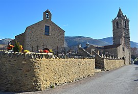 The church of Saint-Génis and the chapel of the Virgin, in Err | ||
Location of Err  | ||
(2020–2026) Isidore Peyrato[1] | | |
| Area 1 | 25.92 km2 (10.01 sq mi) | |
| Population (2021)[2] | 699 | |
| • Density | 27/km2 (70/sq mi) | |
| Time zone | UTC+01:00 (CET) | |
| • Summer (DST) | UTC+02:00 (CEST) | |
| INSEE/Postal code | 66067 /66800 | |
| Elevation | 1,309–2,911 m (4,295–9,551 ft) (avg. 1,335 m or 4,380 ft) | |
| 1 French Land Register data, which excludes lakes, ponds, glaciers > 1 km2 (0.386 sq mi or 247 acres) and river estuaries. | ||
Err (French pronunciation: [ɛʁ] ⓘ; Catalan: Er, locally [ˈer(t)]) is a commune in the Pyrénées-Orientales department in southern France.
Toponymy
The onomastics of the town name, first attested as Ezerre in 839 AD amongst many later forms, is ultimately mysterious. Linguists generally agree it dates before the dominance of Celtic languages and Latin in ancient Gaul (a dominant hypothesis being a Basque-related Pre-Indo-European name; also see Old European hydronymy). Compare the etymology of similarly-sounding nearby Ur.
Geography
Err is located in the canton of Les Pyrénées catalanes and in the arrondissement of Prades. Err station has rail connections to Villefranche-de-Conflent and Latour-de-Carol.

Places adjacent to Err, Pyrénées-Orientales | |
|---|---|


Population
Graphs are unavailable due to technical issues. There is more info on Phabricator and on MediaWiki.org. |
| Year | Pop. | ±% p.a. |
|---|---|---|
| 1968 | 352 | — |
| 1975 | 370 | +0.71% |
| 1982 | 408 | +1.41% |
| 1990 | 398 | −0.31% |
| 1999 | 551 | +3.68% |
| 2007 | 621 | +1.51% |
| 2012 | 620 | −0.03% |
| 2017 | 673 | +1.65% |
| Source: INSEE[3] | ||
See also
References
- ^ "Répertoire national des élus: les maires". data.gouv.fr, Plateforme ouverte des données publiques françaises (in French). 2 December 2020.
- ^ "Populations légales 2021". The National Institute of Statistics and Economic Studies. 28 December 2023.
- ^ Population en historique depuis 1968, INSEE
Wikimedia Commons has media related to Err.
- v
- t
- e

- L'Albère
- Alénya
- Amélie-les-Bains-Palalda
- Les Angles
- Angoustrine-Villeneuve-des-Escaldes
- Ansignan
- Arboussols
- Argelès-sur-Mer
- Arles-sur-Tech
- Ayguatébia-Talau
- Bages
- Baho
- Baillestavy
- Baixas
- Banyuls-dels-Aspres
- Banyuls-sur-Mer
- Le Barcarès
- La Bastide
- Bélesta
- Bolquère
- Bompas
- Boule-d'Amont
- Bouleternère
- Le Boulou
- Bourg-Madame
- Brouilla
- La Cabanasse
- Cabestany
- Caixas
- Calce
- Calmeilles
- Camélas
- Campôme
- Campoussy
- Canaveilles
- Canet-en-Roussillon
- Canohès
- Caramany
- Casefabre
- Cases-de-Pène
- Cassagnes
- Casteil
- Castelnou
- Catllar
- Caudiès-de-Conflent
- Caudiès-de-Fenouillèdes
- Cerbère
- Céretsubpr
- Claira
- Clara-Villerach
- Les Cluses
- Codalet
- Collioure
- Conat
- Corbère
- Corbère-les-Cabanes
- Corneilla-de-Conflent
- Corneilla-del-Vercol
- Corneilla-la-Rivière
- Corsavy
- Coustouges
- Dorres
- Égat
- Elne
- Enveitg
- Err
- Escaro
- Espira-de-Conflent
- Espira-de-l'Agly
- Estagel
- Estavar
- Estoher
- Eus
- Eyne
- Feilluns
- Fenouillet
- Fillols
- Finestret
- Fontpédrouse
- Fontrabiouse
- Font-Romeu-Odeillo-Via
- Formiguères
- Fosse
- Fourques
- Fuilla
- Glorianes
- Ille-sur-Têt
- Joch
- Jujols
- Lamanère
- Lansac
- Laroque-des-Albères
- Latour-Bas-Elne
- Latour-de-Carol
- Latour-de-France
- Lesquerde
- La Llagonne
- Llauro
- Llo
- Llupia
- Mantet
- Marquixanes
- Los Masos
- Matemale
- Maureillas-las-Illas
- Maury
- Millas
- Molitg-les-Bains
- Montalba-le-Château
- Montauriol
- Montbolo
- Montescot
- Montesquieu-des-Albères
- Montferrer
- Mont-Louis
- Montner
- Mosset
- Nahuja
- Néfiach
- Nohèdes
- Nyer
- Olette
- Oms
- Opoul-Périllos
- Oreilla
- Ortaffa
- Osséja
- Palau-de-Cerdagne
- Palau-del-Vidre
- Passa
- Perpignanpref
- Le Perthus
- Peyrestortes
- Pézilla-de-Conflent
- Pézilla-la-Rivière
- Pia
- Planès
- Planèzes
- Pollestres
- Ponteilla
- Porta
- Porté-Puymorens
- Port-Vendres
- Pradessubpr
- Prats-de-Mollo-la-Preste
- Prats-de-Sournia
- Prugnanes
- Prunet-et-Belpuig
- Puyvalador
- Py
- Rabouillet
- Railleu
- Rasiguères
- Réal
- Reynès
- Ria-Sirach
- Rigarda
- Rivesaltes
- Rodès
- Sahorre
- Saillagouse
- Saint-André
- Saint-Arnac
- Saint-Cyprien
- Sainte-Colombe-de-la-Commanderie
- Sainte-Léocadie
- Sainte-Marie-la-Mer
- Saint-Estève
- Saint-Féliu-d'Amont
- Saint-Féliu-d'Avall
- Saint-Génis-des-Fontaines
- Saint-Hippolyte
- Saint-Jean-Lasseille
- Saint-Jean-Pla-de-Corts
- Saint-Laurent-de-Cerdans
- Saint-Laurent-de-la-Salanque
- Saint-Marsal
- Saint-Martin-de-Fenouillet
- Saint-Michel-de-Llotes
- Saint-Nazaire
- Saint-Paul-de-Fenouillet
- Saint-Pierre-dels-Forcats
- Saleilles
- Salses-le-Château
- Sansa
- Sauto
- Serdinya
- Serralongue
- Le Soler
- Sorède
- Souanyas
- Sournia
- Taillet
- Tarerach
- Targasonne
- Taulis
- Taurinya
- Tautavel
- Le Tech
- Terrats
- Théza
- Thuès-Entre-Valls
- Thuir
- Tordères
- Torreilles
- Toulouges
- Tresserre
- Trévillach
- Trilla
- Trouillas
- Ur
- Urbanya
- Valcebollère
- Valmanya
- Vernet-les-Bains
- Villefranche-de-Conflent
- Villelongue-de-la-Salanque
- Villelongue-dels-Monts
- Villemolaque
- Villeneuve-de-la-Raho
- Villeneuve-la-Rivière
- Vinça
- Vingrau
- Vira
- Vivès
- Le Vivier
- pref: prefecture
- subpr: subprefecture
| Authority control databases: National |
|
|---|
 | This Pyrénées-Orientales geographical article is a stub. You can help Wikipedia by expanding it. |
- v
- t
- e


