Monts-sur-Orne
Commune in Normandy, France
Location of Monts-sur-Orne

(2020–2026) Gilles Mallet[1]
1
(2021)[2]
61194 /61150
Monts-sur-Orne (French pronunciation: [mɔ̃ syʁ ɔʁn]) is a commune in the department of Orne, northwestern France. The municipality was established on 1 January 2018 by merger of the former communes of Goulet (the seat), Montgaroult and Sentilly.[3]
Population
The former commune of Sentilly had a 2019 population of 128.[4]
Geography
The commune is made up of the following collection of villages and hamlets, Goulet, Pommereux, Montgaroult, Sentilly, Vaux le Bardoult, Fontaine and Vloger. It also borders the area known as Suisse Normande.[5][6]
The commune has two rivers running through it, the River Orne and one of its tributaries the River Houay.[7][8]
Neighbouring communes[6] | ||||||||||||||||
|---|---|---|---|---|---|---|---|---|---|---|---|---|---|---|---|---|
| ||||||||||||||||


Points of Interest
- Carrière des Monts is a Sensitive Natural Space of Orne covering an area of 2 hectares.[9] The site, in Sentilly is a former Limestone quarry, that makes a suitable home for many insects, attracted by the Thyme and Oregano that grows there.[10]
National Heritage sites
The Commune has three buildings and areas listed as a Monument historique.[11]
- Servin Cross is a 13th century Wayside cross located in Goulet that was listed as a Monument historique in 1955.[12]
- Vaux-le-Bardoult Church is a 14th Century Church located in Vaux le Bardoult that was registered as a Monument in 1972.[13]
- Manoir de Pommereux is a 15th Century manor house located in Pommereux that was listed as a Monument historique in 1926.[14]
-
 Manoir de Pommereux
 -
 Vaux-le-Bardoult church
 -
 Servin Cross
 -
 Montgaroult church
 -
 War Memorial in Goulet
 -
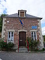 Sentilly Mayors office


See also
References
Wikimedia Commons has media related to Monts-sur-Orne.
- ^ "Répertoire national des élus: les maires" (in French). data.gouv.fr, Plateforme ouverte des données publiques françaises. 13 September 2022.
- ^ "Populations légales 2021". The National Institute of Statistics and Economic Studies. 28 December 2023.
- ^ Arrêté préfectoral 18 December 2017 (in French)
- ^ Téléchargement du fichier d'ensemble des populations légales en 2019, INSEE
- ^ "Map of Suiss Normande" (PDF).
- ^ a b "Monts-sur-Orne · 61150, France". Monts-sur-Orne · 61150, France.
- ^ Sandre. "Fiche cours d'eau - L'Houay (I2129000)".
- ^ Sandre. "Fiche cours d'eau - L'Orne (I2--0200)".
- ^ "Espaces Naturels Sensibles de l'Orne | Conservatoires d'espaces naturels de Normandie". cen-normandie.fr.
- ^ "La Carrière des Monts et Sablonettes MONTS-SUR-ORNE : Normandy Tourism". Normandy Tourism, France.
- ^ "Les Monuments Historiques en Orne - 61". monumentum.fr.
- ^ "Croix de carrefour dite Croix Servin". www.pop.culture.gouv.fr.
- ^ "Eglise de Vaux-le-Bardoult". www.pop.culture.gouv.fr.
- ^ "Manoir de Pommereux". www.pop.culture.gouv.fr.
- v
- t
- e

- L'Aigle
- Alençonpref
- Almenêches
- Appenai-sous-Bellême
- Argentansubpr
- Les Aspres
- Athis-Val de Rouvre
- Aube
- Aubry-le-Panthou
- Aubusson
- Auguaise
- Aunay-les-Bois
- Aunou-le-Faucon
- Aunou-sur-Orne
- Les Authieux-du-Puits
- Avernes-Saint-Gourgon
- Avoine
- Avrilly
- Bagnoles de l'Orne Normandie
- Bailleul
- Banvou
- Barville
- Bazoches-au-Houlme
- Bazoches-sur-Hoëne
- La Bazoque
- Beaufai
- Beaulieu
- Beauvain
- Belfonds
- Belforêt-en-Perche
- Bellavilliers
- Bellême
- La Bellière
- Bellou-en-Houlme
- Bellou-le-Trichard
- Berd'huis
- Berjou
- Bizou
- Boëcé
- Boischampré
- Boissei-la-Lande
- Boitron
- Bonnefoi
- Bonsmoulins
- Le Bosc-Renoult
- Boucé
- Le Bouillon
- Brethel
- Bretoncelles
- Brieux
- Briouze
- Brullemail
- Buré
- Bures
- Bursard
- Cahan
- Caligny
- Camembert
- Canapville
- Carrouges
- Ceaucé
- Le Cercueil
- Cerisé
- Cerisy-Belle-Étoile
- Ceton
- Chahains
- Chailloué
- Le Chalange
- Champcerie
- Le Champ-de-la-Pierre
- Les Champeaux
- Champeaux-sur-Sarthe
- Champ-Haut
- Champosoult
- Champsecret
- Chandai
- Chanu
- La Chapelle-au-Moine
- La Chapelle-Biche
- La Chapelle-Montligeon
- La Chapelle-près-Sées
- La Chapelle-Souëf
- La Chapelle-Viel
- Charencey
- Le Château-d'Almenêches
- Le Châtellier
- Chaumont
- La Chaux
- Chemilli
- Ciral
- Cisai-Saint-Aubin
- Colombiers
- Comblot
- Commeaux
- Condé-sur-Sarthe
- Corbon
- Coudehard
- Coulimer
- Coulmer
- Coulonces
- La Coulonche
- Coulonges-sur-Sarthe
- Courgeon
- Courgeoût
- Cour-Maugis sur Huisne
- Courtomer
- Craménil
- Croisilles
- Crouttes
- Crulai
- Cuissai
- Dame-Marie
- Damigny
- Domfront en Poiraie
- Dompierre
- Durcet
- Échalou
- Échauffour
- Écorcei
- Écorches
- Écouché-les-Vallées
- Écouves
- Essay
- Faverolles
- Fay
- Feings
- La Ferrière-au-Doyen
- La Ferrière-aux-Étangs
- La Ferrière-Béchet
- La Ferrière-Bochard
- Ferrières-la-Verrerie
- La Ferté-en-Ouche
- La Ferté-Macé
- Flers
- Fleuré
- Fontaine-les-Bassets
- Francheville
- La Fresnaie-Fayel
- Fresnay-le-Samson
- Gacé
- Gandelain
- Gâprée
- Les Genettes
- La Genevraie
- Giel-Courteilles
- Ginai
- Godisson
- La Gonfrière
- Gouffern en Auge
- Le Grais
- Guêprei
- Guerquesalles
- Habloville
- Hauterive
- Héloup
- L'Hôme-Chamondot
- Igé
- Irai
- Joué-du-Bois
- Joué-du-Plain
- Juvigny-sur-Orne
- Juvigny Val d'Andaine
- Lalacelle
- Laleu
- La Lande-de-Goult
- La Lande-de-Lougé
- La Lande-Patry
- La Lande-Saint-Siméon
- Landigou
- Landisacq
- Larré
- Lignères
- Lignou
- Loisail
- Longny les Villages
- Lonlay-l'Abbaye
- Lonlay-le-Tesson
- Lonrai
- Lougé-sur-Maire
- Louvières-en-Auge
- Macé
- La Madeleine-Bouvet
- Le Mage
- Magny-le-Désert
- Mahéru
- Mantilly
- Marchemaisons
- Mardilly
- Mauves-sur-Huisne
- Médavy
- Méhoudin
- Le Mêle-sur-Sarthe
- Le Ménil-Bérard
- Le Ménil-Broût
- Le Ménil-Ciboult
- Le Ménil-de-Briouze
- Ménil-Erreux
- Ménil-Froger
- Ménil-Gondouin
- Le Ménil-Guyon
- Ménil-Hermei
- Ménil-Hubert-en-Exmes
- Ménil-Hubert-sur-Orne
- Le Ménil-Scelleur
- Le Ménil-Vicomte
- Ménil-Vin
- Les Menus
- Le Merlerault
- Merri
- La Mesnière
- Messei
- Mieuxcé
- Moncy
- Montabard
- Montchevrel
- Montgaudry
- Montilly-sur-Noireau
- Montmerrei
- Mont-Ormel
- Montreuil-au-Houlme
- Montreuil-la-Cambe
- Les Monts d'Andaine
- Montsecret-Clairefougère
- Monts-sur-Orne
- Mortagne-au-Perchesubpr
- Mortrée
- La Motte-Fouquet
- Moulins-la-Marche
- Moulins-sur-Orne
- Moutiers-au-Perche
- Neauphe-sous-Essai
- Neauphe-sur-Dive
- Nécy
- Neuilly-le-Bisson
- Neuville-sur-Touques
- Neuvy-au-Houlme
- Nonant-le-Pin
- Occagnes
- Ommoy
- L'Orée-d'Écouves
- Orgères
- Origny-le-Roux
- Pacé
- Parfondeval
- Le Pas-Saint-l'Homer
- Passais Villages
- Perche en Nocé
- Perrou
- Pervenchères
- Le Pin-au-Haras
- Le Pin-la-Garenne
- Planches
- Le Plantis
- Pointel
- Pontchardon
- Pouvrai
- Putanges-le-Lac
- Rai
- Rânes
- Rémalard en Perche
- Le Renouard
- Résenlieu
- Réveillon
- Ri
- Rives d'Andaine
- La Roche-Mabile
- Roiville
- Rônai
- Rouperroux
- Sablons-sur-Huisne
- Sai
- Saint-Agnan-sur-Sarthe
- Saint-André-de-Briouze
- Saint-André-de-Messei
- Saint-Aquilin-de-Corbion
- Saint-Aubin-d'Appenai
- Saint-Aubin-de-Bonneval
- Saint-Aubin-de-Courteraie
- Saint-Bômer-les-Forges
- Saint-Brice
- Saint-Brice-sous-Rânes
- Saint-Céneri-le-Gérei
- Saint-Christophe-de-Chaulieu
- Saint-Clair-de-Halouze
- Saint-Cyr-la-Rosière
- Saint-Denis-sur-Huisne
- Saint-Denis-sur-Sarthon
- Sainte-Céronne-lès-Mortagne
- Sainte-Gauburge-Sainte-Colombe
- Sainte-Honorine-la-Chardonne
- Sainte-Honorine-la-Guillaume
- Saint-Ellier-les-Bois
- Sainte-Marguerite-de-Carrouges
- Sainte-Marie-la-Robert
- Sainte-Opportune
- Sainte-Scolasse-sur-Sarthe
- Saint-Evroult-de-Montfort
- Saint-Evroult-Notre-Dame-du-Bois
- Saint-Fraimbault
- Saint-Fulgent-des-Ormes
- Saint-Georges-d'Annebecq
- Saint-Georges-des-Groseillers
- Saint-Germain-d'Aunay
- Saint-Germain-de-Clairefeuille
- Saint-Germain-de-la-Coudre
- Saint-Germain-de-Martigny
- Saint-Germain-des-Grois
- Saint-Germain-du-Corbéis
- Saint-Germain-le-Vieux
- Saint-Gervais-des-Sablons
- Saint-Gervais-du-Perron
- Saint-Gilles-des-Marais
- Saint-Hilaire-de-Briouze
- Saint-Hilaire-le-Châtel
- Saint-Hilaire-sur-Erre
- Saint-Hilaire-sur-Risle
- Saint-Jouin-de-Blavou
- Saint-Julien-sur-Sarthe
- Saint-Lambert-sur-Dive
- Saint-Langis-lès-Mortagne
- Saint-Léger-sur-Sarthe
- Saint-Léonard-des-Parcs
- Saint-Mard-de-Réno
- Saint-Mars-d'Égrenne
- Saint-Martin-d'Écublei
- Saint-Martin-des-Landes
- Saint-Martin-des-Pézerits
- Saint-Martin-du-Vieux-Bellême
- Saint-Martin-l'Aiguillon
- Saint-Michel-Tubœuf
- Saint-Nicolas-des-Bois
- Saint-Nicolas-de-Sommaire
- Saint-Ouen-de-Sécherouvre
- Saint-Ouen-le-Brisoult
- Saint-Ouen-sur-Iton
- Saint-Patrice-du-Désert
- Saint-Paul
- Saint-Philbert-sur-Orne
- Saint-Pierre-d'Entremont
- Saint-Pierre-des-Loges
- Saint-Pierre-du-Regard
- Saint-Pierre-la-Bruyère
- Saint-Quentin-de-Blavou
- Saint-Quentin-les-Chardonnets
- Saint-Roch-sur-Égrenne
- Saint-Sauveur-de-Carrouges
- Saint-Sulpice-sur-Risle
- Saint-Symphorien-des-Bruyères
- Saires-la-Verrerie
- Le Sap-André
- Sap-en-Auge
- Sarceaux
- Sées
- La Selle-la-Forge
- Semallé
- Sévigny
- Sevrai
- Soligny-la-Trappe
- Suré
- Tanques
- Tanville
- Tellières-le-Plessis
- Tessé-Froulay
- Ticheville
- Tinchebray-Bocage
- Torchamp
- Touquettes
- Tournai-sur-Dive
- Tourouvre au Perche
- Trémont
- La Trinité-des-Laitiers
- Trun
- Val-au-Perche
- Valframbert
- Vaunoise
- Les Ventes-de-Bourse
- La Ventrouze
- Verrières
- Vidai
- Vieux-Pont
- Villedieu-lès-Bailleul
- Villiers-sous-Mortagne
- Vimoutiers
- Vitrai-sous-Laigle
- Les Yveteaux
- pref: prefecture
- subpr: subprefecture
 | This Orne geographical article is a stub. You can help Wikipedia by expanding it. |
- v
- t
- e


