Gilpin Peak
Mountain in the state of Colorado


Gilpin Peak
Colorado
Sneffels Range[2]
Grays Peak, Colorado[3]
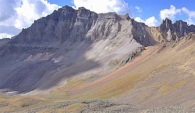
Gilpin Peak is a high mountain summit in the Sneffels Range of the Rocky Mountains of North America. The 13,700-foot (4,176 m) thirteener is located in the Mount Sneffels Wilderness of Uncompahgre National Forest, 3.5 miles (5.6 km) north-northeast (bearing 23°) of the Town of Telluride, Colorado, United States, on the drainage divide between Ouray County and San Miguel County.[1][2][3] Gilpin Peak was named in honor of William Gilpin, the first Governor of the Territory of Colorado.[4]

Climate
According to the Köppen climate classification system, Gilpin Peak is located in an alpine subarctic climate zone with long, cold, snowy winters, and cool to warm summers.[5] Due to its altitude, it receives precipitation all year, as snow in winter, and as thunderstorms in summer, with a dry period in late spring. Precipitation runoff from the mountain drains into tributaries of the San Miguel and the Uncompahgre Rivers.

See also
 Geology portal
 Geography portal
 North America portal
 United States portal
 Colorado portal
 Mountains portal


- List of Colorado mountain ranges
- List of Colorado mountain summits
- List of Colorado county high points
References
- ^ a b The elevation of Gilpin Peak includes an adjustment of +1.859 m (+6.10 ft) from NGVD 29 to NAVD 88.
- ^ a b c d e f "Gilpin Peak, Colorado". Peakbagger.com. Retrieved November 5, 2014.
- ^ a b c d "Gilpin Peak". Geographic Names Information System. United States Geological Survey, United States Department of the Interior. Retrieved November 5, 2014.
- ^ Gannett, Henry (1905). The Origin of Certain Place Names in the United States. Govt. Print. Off. pp. 138.
- ^ Peel, M. C.; Finlayson, B. L.; McMahon, T. A. (2007). "Updated world map of the Köppen−Geiger climate classification". Hydrol. Earth Syst. Sci. 11. ISSN 1027-5606.
External links
 Media related to Gilpin Peak at Wikimedia Commons
Gilpin Peak at Wikipedia's sister projects
 Definitions from Wiktionary
 News from Wikinews
 Quotations from Wikiquote
 Texts from Wikisource
 Textbooks from Wikibooks
 Resources from Wikiversity
- v
- t
- e

- Mount Garfield
- Aspen Mountain
- Capitol Peak
- Castle Peak
- Cathedral Peak
- Chair Mountain
- Crested Butte
- Gothic Mountain
- Italian Mountain
- Maroon Bells
- Mount Emmons
- Mount Owen
- Mount Sopris
- Pyramid Peak
- Snowmass Mountain
- Snowmass Peak
- Treasure Mountain
- Black Mountain (Moffat County)
- Columbus Mountain
- Elk Mountain (Routt County)
- Hahns Peak
- Flat Top Mountain
- Sleepy Cat Peak
- Eagles Nest
- Jacque Peak
- Meridian Peak
- Mount Powell
- The Spider
- Crater Peak
- North Mamm Peak
- Clark Peak
- Arkansas Hills
- Clinton Peak
- Dyer Mountain
- Gemini Peak
- Horseshoe Mountain
- Mount Arkansas
- Mount Bross
- Mount Buckskin
- Mount Democrat
- Mount Lincoln
- Mount Sheridan
- Mount Sherman
- Pacific Peak
- West Buffalo Peak
- Elk Mountain (Grand County)
- Parkview Mountain
- Radial Mountain
- Whiteley Peak
| Sangre de Cristo Range |
|
|---|---|
| Wet Mountains |
|
| Others |
|
| Collegiate Peaks |
|
|---|---|
| Others |
|
- Crystal Peak
- Fletcher Mountain
- Peak 10
- Peak One
- Quandary Peak
- Tenmile Peak
- Bear Mountain
- Blair Mountain
- Chalk Mountains
- Cochetopa Hills
- Dawson Butte
- Diamond Peak
- Flirtation Peak
- Granite Peak
- Grand Hogback
- Grannys Nipple
- Horsefly Peak
- Lead Mountain (Grand County)
- Mount Neva
- Powell Peak
- San Luis Hills
- Storm King Mountain
- Terrible Mountain
- Two Buttes
- Ute Mountain
 | This Colorado state location article is a stub. You can help Wikipedia by expanding it. |
- v
- t
- e


