Joyeuse, Ardèche
You can help expand this article with text translated from the corresponding article in French. (December 2008) Click [show] for important translation instructions.
- View a machine-translated version of the French article.
- Machine translation, like DeepL or Google Translate, is a useful starting point for translations, but translators must revise errors as necessary and confirm that the translation is accurate, rather than simply copy-pasting machine-translated text into the English Wikipedia.
- Do not translate text that appears unreliable or low-quality. If possible, verify the text with references provided in the foreign-language article.
- You must provide copyright attribution in the edit summary accompanying your translation by providing an interlanguage link to the source of your translation. A model attribution edit summary is
Content in this edit is translated from the existing French Wikipedia article at [[:fr:Joyeuse (Ardèche)]]; see its history for attribution. - You may also add the template
{{Translated|fr|Joyeuse (Ardèche)}}to the talk page. - For more guidance, see Wikipedia:Translation.
Commune in Auvergne-Rhône-Alpes, France
Joyeuse Juèsa (Occitan) | ||
|---|---|---|
Commune | ||
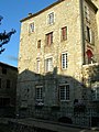
 The railway station car park and the D104 road, with the chateau and the church beyond | ||
 Coat of arms | ||
Location of Joyeuse  | ||
(2020–2026) Brigitte Pantoustier[1] | | |
| Area 1 | 13.04 km2 (5.03 sq mi) | |
| Population (2021)[2] | 1,745 | |
| • Density | 130/km2 (350/sq mi) | |
| Time zone | UTC+01:00 (CET) | |
| • Summer (DST) | UTC+02:00 (CEST) | |
| INSEE/Postal code | 07110 /07260 | |
| Elevation | 120–323 m (394–1,060 ft) (avg. 180 m or 590 ft) | |
| 1 French Land Register data, which excludes lakes, ponds, glaciers > 1 km2 (0.386 sq mi or 247 acres) and river estuaries. | ||
Joyeuse (French: [ʒwajøz] ⓘ; Occitan: Juèsa) is a commune in the Ardèche department in the Auvergne-Rhône-Alpes region in southern France, supposedly named for Charlemagne's legendary sword.
Geography
Joyeuse lies in the historic region of Bas-Vivarais, in the valley of the Beaume, a tributary of the Ardèche.
Population
|
| ||||||||||||||||||||||||||||||||||||||||||||||||||||||||||||||||||||||||||||||||||||||||||||||||||||||||||||||||||
| Source: EHESS[3] and INSEE (1968-2017)[4] | |||||||||||||||||||||||||||||||||||||||||||||||||||||||||||||||||||||||||||||||||||||||||||||||||||||||||||||||||||
Personalities
- Marcus Jallius Bassus, Roman consul, whose tomb is near Joyeuse
- Charlemagne, founder of Joyeuse according to tradition
- Duke Anne de Joyeuse
- Cardinal François de Joyeuse
- Duchess Henriette Catherine de Joyeuse
- la Grande Mademoiselle
- François Boissel
- See List of Dukes of Joyeuse
Sights
- The Château de Joyeuse is a classed as a monument historique. An earlier castle was largely destroyed and rebuilt in the 16th century. Today it serves as the mairie.
- The Oratorian college is a monument historique. It was founded by Duchess Henriette in 1617 with the permission of Pope Paul V. It served as an educational institution until the French Revolution. It is now the home of a museum dealing with the cultivation and use of the sweet chestnut, from foodstuffs to furniture.
- The church of Saint Peter, a third monument historique, dates from the eleventh century. The church was reconstructed in the 17th century.
- The hôtel de Montravel was built between the 12th and 14th centuries although the front façade dates from 1775.
- Museums include a museum of local history, the Espace historique et légendaire, and the Maison de la caricature et du dessin d'humour, a museum of caricature.
Twin town
Joyeuse is twinned with Jupille and Vilassar de Dalt.
Gallery
-
 Château de Joyeuse
 -
 Former college of the Oratorians
 -
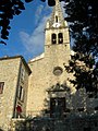 Church of Saint Peter


See also
References
- ^ "Répertoire national des élus: les maires" (in French). data.gouv.fr, Plateforme ouverte des données publiques françaises. 13 September 2022.
- ^ "Populations légales 2021". The National Institute of Statistics and Economic Studies. 28 December 2023.
- ^ Des villages de Cassini aux communes d'aujourd'hui: Commune data sheet Joyeuse, EHESS (in French).
- ^ Population en historique depuis 1968, INSEE
External links
Wikimedia Commons has media related to Joyeuse, Ardèche.
- Mairie of Joyeuse
- CPPJ - Culture et Patrimoine en Pays Joyeusain
- Chestnut museum (pays-beaumedrobie.com) at archive.today (archived 2012-09-07)
- Images et textes
- v
- t
- e

- Accons
- Ailhon
- Aizac
- Ajoux
- Alba-la-Romaine
- Albon-d'Ardèche
- Alboussière
- Alissas
- Andance
- Annonay
- Arcens
- Ardoix
- Arlebosc
- Arras-sur-Rhône
- Les Assions
- Astet
- Aubenas
- Aubignas
- Baix
- Balazuc
- Banne
- Barnas
- Le Béage
- Beauchastel
- Beaulieu
- Beaumont
- Beauvène
- Belsentes
- Berrias-et-Casteljau
- Berzème
- Bessas
- Bidon
- Boffres
- Bogy
- Borée
- Borne
- Boucieu-le-Roi
- Boulieu-lès-Annonay
- Bourg-Saint-Andéol
- Bozas
- Brossainc
- Burzet
- Cellier-du-Luc
- Chalencon
- Le Chambon
- Chambonas
- Champagne
- Champis
- Chandolas
- Chanéac
- Charmes-sur-Rhône
- Charnas
- Chassiers
- Châteaubourg
- Châteauneuf-de-Vernoux
- Chauzon
- Chazeaux
- Cheminas
- Le Cheylard
- Chirols
- Chomérac
- Colombier-le-Cardinal
- Colombier-le-Jeune
- Colombier-le-Vieux
- Cornas
- Coucouron
- Coux
- Le Crestet
- Creysseilles
- Cros-de-Géorand
- Cruas
- Darbres
- Davézieux
- Désaignes
- Devesset
- Dompnac
- Dornas
- Dunière-sur-Eyrieux
- Eclassan
- Empurany
- Étables
- Fabras
- Faugères
- Félines
- Flaviac
- Fons
- Freyssenet
- Genestelle
- Gilhac-et-Bruzac
- Gilhoc-sur-Ormèze
- Gluiras
- Glun
- Gourdon
- Gras
- Gravières
- Grospierres
- Guilherand-Granges
- Issamoulenc
- Issanlas
- Issarlès
- Jaujac
- Jaunac
- Joannas
- Joyeuse
- Juvinas
- Labastide-de-Virac
- Labastide-sur-Bésorgues
- Labatie-d'Andaure
- Labeaume
- Labégude
- Lablachère
- Laboule
- Le Lac-d'Issarlès
- Lachamp-Raphaël
- Lachapelle-Graillouse
- Lachapelle-sous-Aubenas
- Lachapelle-sous-Chanéac
- Lafarre
- Lagorce
- Lalevade-d'Ardèche
- Lalouvesc
- Lamastre
- Lanarce
- Lanas
- Largentièresubpr
- Larnas
- Laurac-en-Vivarais
- Laveyrune
- Lavillatte
- Lavilledieu
- Laviolle
- Lemps
- Lentillères
- Lespéron
- Limony
- Loubaresse
- Lussas
- Lyas
- Malarce-sur-la-Thines
- Malbosc
- Marcols-les-Eaux
- Mariac
- Mars
- Mauves
- Mayres
- Mazan-l'Abbaye
- Mercuer
- Meyras
- Meysse
- Mézilhac
- Mirabel
- Monestier
- Montpezat-sous-Bauzon
- Montréal
- Montselgues
- Nozières
- Les Ollières-sur-Eyrieux
- Orgnac-l'Aven
- Ozon
- Pailharès
- Payzac
- Peaugres
- Péreyres
- Peyraud
- Le Plagnal
- Planzolles
- Plats
- Pont-de-Labeaume
- Pourchères
- Le Pouzin
- Prades
- Pradons
- Pranles
- Préaux
- Privaspref
- Prunet
- Quintenas
- Ribes
- Rochecolombe
- Rochemaure
- Rochepaule
- Rocher
- Rochessauve
- La Rochette
- Rocles
- Roiffieux
- Rompon
- Rosières
- Le Roux
- Ruoms
- Sablières
- Sagnes-et-Goudoulet
- Saint-Agrève
- Saint-Alban-Auriolles
- Saint-Alban-d'Ay
- Saint-Alban-en-Montagne
- Saint-Andéol-de-Berg
- Saint-Andéol-de-Fourchades
- Saint-Andéol-de-Vals
- Saint-André-de-Cruzières
- Saint-André-en-Vivarais
- Saint-André-Lachamp
- Saint-Apollinaire-de-Rias
- Saint-Barthélemy-Grozon
- Saint-Barthélemy-le-Meil
- Saint-Barthélemy-le-Plain
- Saint-Basile
- Saint-Bauzile
- Saint-Christol
- Saint-Cierge-la-Serre
- Saint-Cierge-sous-le-Cheylard
- Saint-Cirgues-de-Prades
- Saint-Cirgues-en-Montagne
- Saint-Clair
- Saint-Clément
- Saint-Cyr
- Saint-Désirat
- Saint-Didier-sous-Aubenas
- Sainte-Eulalie
- Sainte-Marguerite-Lafigère
- Saint-Étienne-de-Boulogne
- Saint-Étienne-de-Fontbellon
- Saint-Étienne-de-Lugdarès
- Saint-Étienne-de-Serre
- Saint-Étienne-de-Valoux
- Saint-Félicien
- Saint-Fortunat-sur-Eyrieux
- Saint-Genest-de-Beauzon
- Saint-Genest-Lachamp
- Saint-Georges-les-Bains
- Saint-Germain
- Saint-Gineys-en-Coiron
- Saint-Jacques-d'Atticieux
- Saint-Jean-Chambre
- Saint-Jean-de-Muzols
- Saint-Jean-le-Centenier
- Saint-Jean-Roure
- Saint-Jeure-d'Andaure
- Saint-Jeure-d'Ay
- Saint-Joseph-des-Bancs
- Saint-Julien-d'Intres
- Saint-Julien-du-Gua
- Saint-Julien-du-Serre
- Saint-Julien-en-Saint-Alban
- Saint-Julien-le-Roux
- Saint-Julien-Vocance
- Saint-Just-d'Ardèche
- Saint-Lager-Bressac
- Saint-Laurent-du-Pape
- Saint-Laurent-les-Bains-Laval-d'Aurelle
- Saint-Laurent-sous-Coiron
- Saint-Marcel-d'Ardèche
- Saint-Marcel-lès-Annonay
- Saint-Martial
- Saint-Martin-d'Ardèche
- Saint-Martin-de-Valamas
- Saint-Martin-sur-Lavezon
- Saint-Maurice-d'Ardèche
- Saint-Maurice-d'Ibie
- Saint-Maurice-en-Chalencon
- Saint-Mélany
- Saint-Michel-d'Aurance
- Saint-Michel-de-Boulogne
- Saint-Michel-de-Chabrillanoux
- Saint-Montan
- Saint-Paul-le-Jeune
- Saint-Péray
- Saint-Pierre-de-Colombier
- Saint-Pierre-la-Roche
- Saint-Pierre-Saint-Jean
- Saint-Pierre-sur-Doux
- Saint-Pierreville
- Saint-Pons
- Saint-Priest
- Saint-Privat
- Saint-Prix
- Saint-Remèze
- Saint-Romain-d'Ay
- Saint-Romain-de-Lerps
- Saint-Sauveur-de-Cruzières
- Saint-Sauveur-de-Montagut
- Saint-Sernin
- Saint-Sylvestre
- Saint-Symphorien-de-Mahun
- Saint-Symphorien-sous-Chomérac
- Saint-Thomé
- Saint-Victor
- Saint-Vincent-de-Barrès
- Saint-Vincent-de-Durfort
- Salavas
- Les Salelles
- Sampzon
- Sanilhac
- Sarras
- Satillieu
- Savas
- Sceautres
- Sécheras
- Serrières
- Silhac
- La Souche
- Soyons
- Talencieux
- Tauriers
- Le Teil
- Thorrenc
- Thueyts
- Toulaud
- Tournon-sur-Rhônesubpr
- Ucel
- Usclades-et-Rieutord
- Uzer
- Vagnas
- Valgorge
- Vallées-d'Antraigues-Asperjoc
- Vallon-Pont-d'Arc
- Vals-les-Bains
- Valvignères
- Vanosc
- Les Vans
- Vaudevant
- Vernon
- Vernosc-lès-Annonay
- Vernoux-en-Vivarais
- Vesseaux
- Veyras
- Villeneuve-de-Berg
- Villevocance
- Vinezac
- Vinzieux
- Vion
- Viviers
- Vocance
- Vogüé
- La Voulte-sur-Rhône
- pref: prefecture
- subpr: subprefecture
Authority control databases | |
|---|---|
| International |
|
| National |
|
| Other |
|
 | This Ardèche geographical article is a stub. You can help Wikipedia by expanding it. |
- v
- t
- e


