Les Ollières-sur-Eyrieux
You can help expand this article with text translated from the corresponding article in French. (December 2008) Click [show] for important translation instructions.
- View a machine-translated version of the French article.
- Machine translation, like DeepL or Google Translate, is a useful starting point for translations, but translators must revise errors as necessary and confirm that the translation is accurate, rather than simply copy-pasting machine-translated text into the English Wikipedia.
- Do not translate text that appears unreliable or low-quality. If possible, verify the text with references provided in the foreign-language article.
- You must provide copyright attribution in the edit summary accompanying your translation by providing an interlanguage link to the source of your translation. A model attribution edit summary is
Content in this edit is translated from the existing French Wikipedia article at [[:fr:Les Ollières-sur-Eyrieux]]; see its history for attribution. - You may also add the template
{{Translated|fr|Les Ollières-sur-Eyrieux}}to the talk page. - For more guidance, see Wikipedia:Translation.
Commune in Auvergne-Rhône-Alpes, France
Les Ollières-sur-Eyrieux | ||
|---|---|---|
Commune | ||
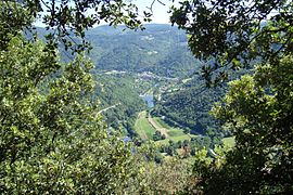 A view towards Les Ollières-sur-Eyrieux | ||
Location of Les Ollières-sur-Eyrieux  | ||
(2020–2026) Hélène Baptiste[1] | | |
| Area 1 | 7.58 km2 (2.93 sq mi) | |
| Population (2021)[2] | 1,015 | |
| • Density | 130/km2 (350/sq mi) | |
| Time zone | UTC+01:00 (CET) | |
| • Summer (DST) | UTC+02:00 (CEST) | |
| INSEE/Postal code | 07167 /07360 | |
| Elevation | 157–400 m (515–1,312 ft) | |
| 1 French Land Register data, which excludes lakes, ponds, glaciers > 1 km2 (0.386 sq mi or 247 acres) and river estuaries. | ||
Les Ollières-sur-Eyrieux (French pronunciation: [le.z‿ɔljɛʁ syʁ eʁjø], literally Les Ollières on Eyrieux; Occitan: Las Olièras) is a commune in the Ardèche department in southern France.
The nearest towns are Privas and Saint-Sauveur-de-Montagut.
History
The first records of a settlement can be dated back to the 12th century. Situated on the banks of the river Eyrieux (a tributary to the Rhône), Les Ollières (as it is often shortened to by the local people) became a central location for the treatment and processing of silk in the early 18th century. The silk (and later different textiles) industry was to feature heavily in the surrounding area.
21st century
The village has now become a tourist location, attracting many Dutch, German, Swiss and English tourists to its many camp sites during the summer months. Some tourists have started to renovate old cottages and set up permanent or holiday homes in the area.
Population
| Year | Pop. | ±% p.a. |
|---|---|---|
| 1968 | 960 | — |
| 1975 | 788 | −2.78% |
| 1982 | 793 | +0.09% |
| 1990 | 769 | −0.38% |
| 1999 | 797 | +0.40% |
| 2009 | 927 | +1.52% |
| 2014 | 957 | +0.64% |
| 2020 | 1,011 | +0.92% |
| Source: INSEE[3] | ||
Transportation
For the people of Les Ollières a daily bus service runs to Valence and Privas.
See also
References
- ^ "Répertoire national des élus: les maires". data.gouv.fr, Plateforme ouverte des données publiques françaises (in French). 9 August 2021.
- ^ "Populations légales 2021". The National Institute of Statistics and Economic Studies. 28 December 2023.
- ^ Population en historique depuis 1968, INSEE
Wikimedia Commons has media related to Les Ollières-sur-Eyrieux.
- v
- t
- e

- Accons
- Ailhon
- Aizac
- Ajoux
- Alba-la-Romaine
- Albon-d'Ardèche
- Alboussière
- Alissas
- Andance
- Annonay
- Arcens
- Ardoix
- Arlebosc
- Arras-sur-Rhône
- Les Assions
- Astet
- Aubenas
- Aubignas
- Baix
- Balazuc
- Banne
- Barnas
- Le Béage
- Beauchastel
- Beaulieu
- Beaumont
- Beauvène
- Belsentes
- Berrias-et-Casteljau
- Berzème
- Bessas
- Bidon
- Boffres
- Bogy
- Borée
- Borne
- Boucieu-le-Roi
- Boulieu-lès-Annonay
- Bourg-Saint-Andéol
- Bozas
- Brossainc
- Burzet
- Cellier-du-Luc
- Chalencon
- Le Chambon
- Chambonas
- Champagne
- Champis
- Chandolas
- Chanéac
- Charmes-sur-Rhône
- Charnas
- Chassiers
- Châteaubourg
- Châteauneuf-de-Vernoux
- Chauzon
- Chazeaux
- Cheminas
- Le Cheylard
- Chirols
- Chomérac
- Colombier-le-Cardinal
- Colombier-le-Jeune
- Colombier-le-Vieux
- Cornas
- Coucouron
- Coux
- Le Crestet
- Creysseilles
- Cros-de-Géorand
- Cruas
- Darbres
- Davézieux
- Désaignes
- Devesset
- Dompnac
- Dornas
- Dunière-sur-Eyrieux
- Eclassan
- Empurany
- Étables
- Fabras
- Faugères
- Félines
- Flaviac
- Fons
- Freyssenet
- Genestelle
- Gilhac-et-Bruzac
- Gilhoc-sur-Ormèze
- Gluiras
- Glun
- Gourdon
- Gras
- Gravières
- Grospierres
- Guilherand-Granges
- Issamoulenc
- Issanlas
- Issarlès
- Jaujac
- Jaunac
- Joannas
- Joyeuse
- Juvinas
- Labastide-de-Virac
- Labastide-sur-Bésorgues
- Labatie-d'Andaure
- Labeaume
- Labégude
- Lablachère
- Laboule
- Le Lac-d'Issarlès
- Lachamp-Raphaël
- Lachapelle-Graillouse
- Lachapelle-sous-Aubenas
- Lachapelle-sous-Chanéac
- Lafarre
- Lagorce
- Lalevade-d'Ardèche
- Lalouvesc
- Lamastre
- Lanarce
- Lanas
- Largentièresubpr
- Larnas
- Laurac-en-Vivarais
- Laveyrune
- Lavillatte
- Lavilledieu
- Laviolle
- Lemps
- Lentillères
- Lespéron
- Limony
- Loubaresse
- Lussas
- Lyas
- Malarce-sur-la-Thines
- Malbosc
- Marcols-les-Eaux
- Mariac
- Mars
- Mauves
- Mayres
- Mazan-l'Abbaye
- Mercuer
- Meyras
- Meysse
- Mézilhac
- Mirabel
- Monestier
- Montpezat-sous-Bauzon
- Montréal
- Montselgues
- Nozières
- Les Ollières-sur-Eyrieux
- Orgnac-l'Aven
- Ozon
- Pailharès
- Payzac
- Peaugres
- Péreyres
- Peyraud
- Le Plagnal
- Planzolles
- Plats
- Pont-de-Labeaume
- Pourchères
- Le Pouzin
- Prades
- Pradons
- Pranles
- Préaux
- Privaspref
- Prunet
- Quintenas
- Ribes
- Rochecolombe
- Rochemaure
- Rochepaule
- Rocher
- Rochessauve
- La Rochette
- Rocles
- Roiffieux
- Rompon
- Rosières
- Le Roux
- Ruoms
- Sablières
- Sagnes-et-Goudoulet
- Saint-Agrève
- Saint-Alban-Auriolles
- Saint-Alban-d'Ay
- Saint-Alban-en-Montagne
- Saint-Andéol-de-Berg
- Saint-Andéol-de-Fourchades
- Saint-Andéol-de-Vals
- Saint-André-de-Cruzières
- Saint-André-en-Vivarais
- Saint-André-Lachamp
- Saint-Apollinaire-de-Rias
- Saint-Barthélemy-Grozon
- Saint-Barthélemy-le-Meil
- Saint-Barthélemy-le-Plain
- Saint-Basile
- Saint-Bauzile
- Saint-Christol
- Saint-Cierge-la-Serre
- Saint-Cierge-sous-le-Cheylard
- Saint-Cirgues-de-Prades
- Saint-Cirgues-en-Montagne
- Saint-Clair
- Saint-Clément
- Saint-Cyr
- Saint-Désirat
- Saint-Didier-sous-Aubenas
- Sainte-Eulalie
- Sainte-Marguerite-Lafigère
- Saint-Étienne-de-Boulogne
- Saint-Étienne-de-Fontbellon
- Saint-Étienne-de-Lugdarès
- Saint-Étienne-de-Serre
- Saint-Étienne-de-Valoux
- Saint-Félicien
- Saint-Fortunat-sur-Eyrieux
- Saint-Genest-de-Beauzon
- Saint-Genest-Lachamp
- Saint-Georges-les-Bains
- Saint-Germain
- Saint-Gineys-en-Coiron
- Saint-Jacques-d'Atticieux
- Saint-Jean-Chambre
- Saint-Jean-de-Muzols
- Saint-Jean-le-Centenier
- Saint-Jean-Roure
- Saint-Jeure-d'Andaure
- Saint-Jeure-d'Ay
- Saint-Joseph-des-Bancs
- Saint-Julien-d'Intres
- Saint-Julien-du-Gua
- Saint-Julien-du-Serre
- Saint-Julien-en-Saint-Alban
- Saint-Julien-le-Roux
- Saint-Julien-Vocance
- Saint-Just-d'Ardèche
- Saint-Lager-Bressac
- Saint-Laurent-du-Pape
- Saint-Laurent-les-Bains-Laval-d'Aurelle
- Saint-Laurent-sous-Coiron
- Saint-Marcel-d'Ardèche
- Saint-Marcel-lès-Annonay
- Saint-Martial
- Saint-Martin-d'Ardèche
- Saint-Martin-de-Valamas
- Saint-Martin-sur-Lavezon
- Saint-Maurice-d'Ardèche
- Saint-Maurice-d'Ibie
- Saint-Maurice-en-Chalencon
- Saint-Mélany
- Saint-Michel-d'Aurance
- Saint-Michel-de-Boulogne
- Saint-Michel-de-Chabrillanoux
- Saint-Montan
- Saint-Paul-le-Jeune
- Saint-Péray
- Saint-Pierre-de-Colombier
- Saint-Pierre-la-Roche
- Saint-Pierre-Saint-Jean
- Saint-Pierre-sur-Doux
- Saint-Pierreville
- Saint-Pons
- Saint-Priest
- Saint-Privat
- Saint-Prix
- Saint-Remèze
- Saint-Romain-d'Ay
- Saint-Romain-de-Lerps
- Saint-Sauveur-de-Cruzières
- Saint-Sauveur-de-Montagut
- Saint-Sernin
- Saint-Sylvestre
- Saint-Symphorien-de-Mahun
- Saint-Symphorien-sous-Chomérac
- Saint-Thomé
- Saint-Victor
- Saint-Vincent-de-Barrès
- Saint-Vincent-de-Durfort
- Salavas
- Les Salelles
- Sampzon
- Sanilhac
- Sarras
- Satillieu
- Savas
- Sceautres
- Sécheras
- Serrières
- Silhac
- La Souche
- Soyons
- Talencieux
- Tauriers
- Le Teil
- Thorrenc
- Thueyts
- Toulaud
- Tournon-sur-Rhônesubpr
- Ucel
- Usclades-et-Rieutord
- Uzer
- Vagnas
- Valgorge
- Vallées-d'Antraigues-Asperjoc
- Vallon-Pont-d'Arc
- Vals-les-Bains
- Valvignères
- Vanosc
- Les Vans
- Vaudevant
- Vernon
- Vernosc-lès-Annonay
- Vernoux-en-Vivarais
- Vesseaux
- Veyras
- Villeneuve-de-Berg
- Villevocance
- Vinezac
- Vinzieux
- Vion
- Viviers
- Vocance
- Vogüé
- La Voulte-sur-Rhône
- pref: prefecture
- subpr: subprefecture
| Authority control databases |
|
|---|
 | This Ardèche geographical article is a stub. You can help Wikipedia by expanding it. |
- v
- t
- e


