National Register of Historic Places listings in Grays Harbor County, Washington

This is a list of the National Register of Historic Places listings in Grays Harbor County, Washington.
This is intended to be a complete list of the properties and districts on the National Register of Historic Places in Grays Harbor County, Washington, United States. Latitude and longitude coordinates are provided for many National Register properties and districts; these locations may be seen together in an online map.[1]
There are 22 properties and districts listed on the National Register in the county. Another 3 properties were once listed but have been removed.
This National Park Service list is complete through NPS recent listings posted May 31, 2024.[2]
Map all coordinates using OpenStreetMap
Download coordinates as:
- KML
- GPX (all coordinates)
- GPX (primary coordinates)
- GPX (secondary coordinates)
Current listings
| [3] | Name on the Register | Image | Date listed[4] | Location | City or town | Description |
|---|---|---|---|---|---|---|
| 1 | American Veterans Building |  | January 14, 2011 (#10001131) | 307 7th St. 46°58′40″N 123°53′07″W / 46.977778°N 123.885206°W / 46.977778; -123.885206 (American Veterans Building) | Hoquiam | |
| 2 | Carnegie Library | 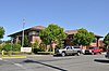 | August 3, 1982 (#82004216) | 621 K St. 46°58′38″N 123°53′09″W / 46.977222°N 123.885833°W / 46.977222; -123.885833 (Carnegie Library) | Hoquiam | Carnegie Libraries of Washington TR |
| 3 | Neil Cooney Mansion | 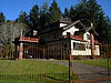 | July 14, 1983 (#83003324) | 802 E. 5th St. 46°57′01″N 123°46′11″W / 46.950358°N 123.769702°W / 46.950358; -123.769702 (Neil Cooney Mansion) | Cosmopolis | |
| 4 | Grays Harbor Light Station | 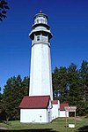 | November 2, 1977 (#77001333) | W of Westport 46°53′18″N 124°06′56″W / 46.888333°N 124.115556°W / 46.888333; -124.115556 (Grays Harbor Light Station) | Westport | |
| 5 | Judge Charles W. Hodgdon House |  | April 27, 2005 (#05000365) | 717 Bluff Ave. 46°59′02″N 123°53′15″W / 46.983754°N 123.887413°W / 46.983754; -123.887413 (Judge Charles W. Hodgdon House) | Hoquiam | |
| 6 | Hoquiam Olympic Stadium | 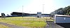 | August 22, 2006 (#06000731) | 2811 Cherry St. 46°59′03″N 123°51′32″W / 46.984167°N 123.858889°W / 46.984167; -123.858889 (Hoquiam Olympic Stadium) | Hoquiam | |
| 7 | Hoquiam River Bridge | 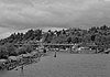 | July 16, 1982 (#82004217) | N of SR 12 46°58′32″N 123°52′32″W / 46.975556°N 123.875556°W / 46.975556; -123.875556 (Hoquiam River Bridge) | Hoquiam | Historic Bridges and Tunnels in Washington TR |
| 8 | Hoquiam's Castle |  | April 11, 1973 (#73001868) | 515 Chenault Ave. 46°59′04″N 123°53′16″W / 46.984444°N 123.887778°W / 46.984444; -123.887778 (Hoquiam's Castle) | Hoquiam | |
| 9 | Hotel Morck |  | May 23, 2016 (#16000294) | 215 S. K Street 46°58′23″N 123°49′08″W / 46.972931°N 123.818752°W / 46.972931; -123.818752 (Hotel Morck) | Aberdeen | |
| 10 | Edward & Laura Hulbert House | 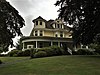 | May 14, 2018 (#100002405) | 807 N M St. 46°58′41″N 123°49′09″W / 46.9780°N 123.8192°W / 46.9780; -123.8192 (Edward & Laura Hulbert House) | Aberdeen | |
| 11 | Kestner Homestead |  | July 13, 2007 (#07000741) | Quinault River Valley, .5 mi. N of Quinault River Ranger Station, along west side of Kestner Creek, Quinault sub-distr 47°30′38″N 123°49′09″W / 47.510536°N 123.819163°W / 47.510536; -123.819163 (Kestner Homestead) | Lake Quinault | |
| 12 | Lake Quinault Lodge |  | July 9, 1998 (#98000846) | South Shore Rd. 47°28′01″N 123°50′50″W / 47.466944°N 123.847222°W / 47.466944; -123.847222 (Lake Quinault Lodge) | Lake Quinault | |
| 13 | Joseph Lytle House |  | July 12, 1990 (#90001073) | 509 Chenault 46°59′03″N 123°53′24″W / 46.984167°N 123.89°W / 46.984167; -123.89 (Joseph Lytle House) | Hoquiam | |
| 14 | Masonic Temple-Hoquiam |  | September 5, 2007 (#07000934) | 510 8th St. 46°58′38″N 123°53′14″W / 46.977222°N 123.887222°W / 46.977222; -123.887222 (Masonic Temple-Hoquiam) | Hoquiam | |
| 15 | Old McCleary Hotel |  | August 1, 1996 (#96000842) | 42 N. Summit Rd. 47°03′34″N 123°15′55″W / 47.059419°N 123.265357°W / 47.059419; -123.265357 (Old McCleary Hotel) | McCleary | |
| 16 | Lachlin McTaggert House | 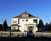 | August 29, 1985 (#85001942) | 2240 L St. 46°58′42″N 123°53′34″W / 46.978333°N 123.892778°W / 46.978333; -123.892778 (Lachlin McTaggert House) | Hoquiam | |
| 17 | Ole Mickelson Cabin | 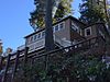 | May 6, 1993 (#92001291) | Lot 46, S shore Lake Quinault, between Willaby Cr. and Falls Cr. 47°27′53″N 123°51′11″W / 47.464722°N 123.853056°W / 47.464722; -123.853056 (Ole Mickelson Cabin) | Quinault | |
| 18 | F. Arnold Polson House and Alex Polson Grounds |  | June 19, 1979 (#79002533) | 1611 Riverside Ave. 46°58′44″N 123°52′45″W / 46.978889°N 123.879167°W / 46.978889; -123.879167 (F. Arnold Polson House and Alex Polson Grounds) | Hoquiam | |
| 19 | Seventh Street Theater |  | August 6, 1987 (#87001334) | 313 Seventh St. 46°58′36″N 123°53′07″W / 46.976667°N 123.885278°W / 46.976667; -123.885278 (Seventh Street Theater) | Hoquiam | |
| 20 | Sierra (motor ship) | 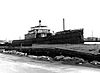 | March 29, 1978 (#78002745) | 1401 Sargent Blvd. 46°58′31″N 123°48′02″W / 46.975278°N 123.800556°W / 46.975278; -123.800556 (Sierra (motor ship)) | Aberdeen | |
| 21 | U.S. Post Office – Hoquiam Main |  | May 30, 1991 (#91000645) | 620 Eighth St. 46°58′30″N 123°53′11″W / 46.975°N 123.886389°W / 46.975; -123.886389 (U.S. Post Office – Hoquiam Main) | Hoquiam | |
| 22 | U.S. Post Office – Montesano Main |  | May 30, 1991 (#91000649) | 211 Pioneer Ave. W. 46°58′46″N 123°36′04″W / 46.979444°N 123.601111°W / 46.979444; -123.601111 (U.S. Post Office – Montesano Main) | Montesano |
Former listings
| [3] | Name on the Register | Image | Date listed | Date removed | Location | City or town | Description |
|---|---|---|---|---|---|---|---|
| 1 | Chow Chow Bridge |  | July 16, 1982 (#82004218) | April 25, 1988 | Spans Quinault River | Taholah | Collapsed in April, 1988.[5] |
| 2 | Finch Building | Upload image | October 13, 1983 (#83004230) | May 25, 2000 | Heron and H Streets | Aberdeen | Damaged by fire on August 21, 1996.[6] |
| 3 | Wishkah River Bridge |  | July 16, 1982 (#82004215) | July 16, 1990 | W. Wishkah Rd. | Greenwood |
See also
- List of National Historic Landmarks in Washington (state)
- National Register of Historic Places listings in Washington state
References
Wikimedia Commons has media related to National Register of Historic Places in Grays Harbor County, Washington.
- ^ The latitude and longitude information provided in this table was derived originally from the National Register Information System, which has been found to be fairly accurate for about 99% of listings. Some locations in this table may have been corrected to current GPS standards.
- ^ National Park Service, United States Department of the Interior, "National Register of Historic Places: Weekly List Actions", retrieved May 31, 2024.
- ^ a b Numbers represent an alphabetical ordering by significant words. Various colorings, defined here, differentiate National Historic Landmarks and historic districts from other NRHP buildings, structures, sites or objects.
- ^ The eight-digit number below each date is the number assigned to each location in the National Register Information System database, which can be viewed by clicking the number.
- ^ "Historic logging bridge falls into Quinault Rvier". The News Tribune. April 11, 1985. p. B3. Retrieved September 3, 2022 – via Newspapers.com.
- ^ "Aberdeen fire guts landmark building". The New York Times. September 2, 1909. p. 9. Retrieved July 21, 2014 – via Newspapers.com.
- v
- t
- e
National Register of Historic Places listings in Washington (state)
by county
- Adams
- Asotin
- Benton
- Chelan
- Clallam
- Clark
- Columbia
- Cowlitz
- Douglas
- Ferry
- Franklin
- Garfield
- Grant
- Grays Harbor
- Island
- Jefferson
- King
- Kitsap
- Kittitas
- Lewis
- Lincoln
- Mason
- Okanogan
- Pacific
- Pend Oreille
- Pierce
- San Juan
- Skagit
- Skamania
- Snohomish
- Spokane
- Stevens
- Thurston
- Wahkiakum
- Walla Walla
- Whatcom
- Whitman
- Yakima

- National Historic Landmarks
- Bridges and Tunnels
| |
|---|---|
| Topics | |
| Lists by state |
|
| Lists by insular areas | |
| Lists by associated state | |
| Other areas | |
| Related | |
| |


Municipalities and communities of Grays Harbor County, Washington, United States | ||
|---|---|---|
County seat: Montesano | ||
| Cities |  | |
| CDPs | ||
| Other communities | ||
| Indian reservations | ||
| Footnotes | ‡This populated place also has portions in an adjacent county or counties | |
| ||


