National Register of Historic Places listings in Jefferson County, Washington

This list presents the full set of buildings, structures, objects, sites, or districts designated on the National Register of Historic Places in Jefferson County, Washington, and offers brief descriptive information about each of them. The National Register recognizes places of national, state, or local historic significance across the United States.[1] Out of over 90,000 National Register sites nationwide,[2] Washington is home to approximately 1,500,[3] and 80 of those are found partially or wholly in Jefferson County.
This National Park Service list is complete through NPS recent listings posted June 28, 2024.[4]
Current listings
| [5] | Name on the Register[6] | Image | Date listed[7] | Location | City or town | Description |
|---|---|---|---|---|---|---|
| 1 | Adventuress | 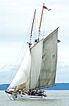 | April 11, 1989 (#89001067) | Sound Experience, PO Box 1390 47°38′06″N 122°19′39″W / 47.635°N 122.3275°W / 47.635; -122.3275 (Adventuress) | Port Townsend | |
| 2 | Frank Bartlett House | 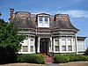 | April 24, 1973 (#73001870) | 314 Polk St. 48°06′54″N 122°45′27″W / 48.115°N 122.7575°W / 48.115; -122.7575 (Frank Bartlett House) | Port Townsend | |
| 3 | Henry Bash House |  | May 16, 1985 (#85001099) | 718 F St. 48°07′17″N 122°46′09″W / 48.1214°N 122.7692°W / 48.1214; -122.7692 (Henry Bash House) | Port Townsend | |
| 4 | Senator William Bishop House and Office | 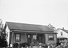 | October 10, 1984 (#84000099) | Chimacum-Center Rd. 48°00′39″N 122°46′05″W / 48.0108°N 122.7681°W / 48.0108; -122.7681 (Senator William Bishop House and Office) | Chimacum | |
| 5 | Botten Cabin |  | July 13, 2007 (#07000729) | 20.9 miles (33.6 km) from Whiskey Bend Trailhead on the Elwha River Trail 47°45′50″N 123°27′16″W / 47.7639°N 123.4544°W / 47.7639; -123.4544 (Botten Cabin) | Port Angeles | |
| 6 | Chimacum Post Office |  | July 14, 1983 (#83003323) | Chimacum-Center Rd. 48°00′39″N 122°46′01″W / 48.0108°N 122.7669°W / 48.0108; -122.7669 (Chimacum Post Office) | Chimacum | |
| 7 | Christian Congregation Church of Port Ludlow |  | January 28, 2021 (#100006061) | 11 Werner Rd. 47°56′12″N 122°42′02″W / 47.9368°N 122.7006°W / 47.9368; -122.7006 (Christian Congregation Church of Port Ludlow) | Port Ludlow | |
| 8 | City Hall | 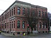 | May 14, 1971 (#71000868) | Water and Madison Sts. 48°06′58″N 122°45′07″W / 48.1161°N 122.7519°W / 48.1161; -122.7519 (City Hall) | Port Townsend | |
| 9 | Coleman-Furlong House | 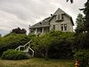 | May 16, 1985 (#85001100) | 1253 Umatilla Ave. 48°07′29″N 122°47′22″W / 48.1247°N 122.7894°W / 48.1247; -122.7894 (Coleman-Furlong House) | Port Townsend | |
| 10 | Dodger Point Fire Lookout |  | July 13, 2007 (#07000736) | Mile 13 of Dodger Point Trail, about 17.2 miles (27.7 km) south of Port Angeles, in Olympic National Park 47°52′27″N 123°30′36″W / 47.8741°N 123.5100°W / 47.8741; -123.5100 (Dodger Point Fire Lookout) | Port Angeles | |
| 11 | Duckabush River Bridge | 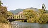 | July 16, 1982 (#82004219) | Spans Duckabush River 47°41′25″N 122°53′52″W / 47.6903°N 122.8978°W / 47.6903; -122.8978 (Duckabush River Bridge) | Duckabush | Historic Bridges and Tunnels in Washington TR |
| 12 | Joel Edwards House | 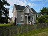 | May 16, 1985 (#85001101) | 913 25th St. 48°07′05″N 122°47′09″W / 48.1181°N 122.7858°W / 48.1181; -122.7858 (Joel Edwards House) | Port Townsend | |
| 13 | Elk Lick Lodge | Upload image | July 13, 2007 (#07000734) | 13 miles (21 km) from Whiskey Bend Trailhead on the Elwha River Trail 47°51′26″N 123°28′09″W / 47.8572°N 123.4692°W / 47.8572; -123.4692 (Elk Lick Lodge) | Port Angeles | |
| 14 | Enchanted Valley Chalet | 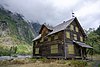 | July 13, 2007 (#07000737) | 13 miles (21 km) upriver from Graves Cr. Trailhead 47°40′31″N 123°23′21″W / 47.6753°N 123.3892°W / 47.6753; -123.3892 (Enchanted Valley Chalet) | Port Angeles | |
| 15 | Thomas Fitzgerald House |  | May 16, 1985 (#85001102) | 832 T St. 48°07′50″N 122°45′49″W / 48.1306°N 122.7636°W / 48.1306; -122.7636 (Thomas Fitzgerald House) | Port Townsend | |
| 16 | Fort Flagler |  | May 3, 1976 (#76001882) | Southeast of Port Townsend on Marrowstone Island 48°05′48″N 122°40′25″W / 48.0967°N 122.6736°W / 48.0967; -122.6736 (Fort Flagler) | Port Townsend | Now a Washington State Park. |
| 17 | Fort Worden |  | March 15, 1974 (#74001954) | Cherry and W Sts. 48°08′20″N 122°45′58″W / 48.1389°N 122.7661°W / 48.1389; -122.7661 (Fort Worden) | Port Townsend | Also a Washington State Park. |
| 18 | Capt. Enoch S. Fowler House | 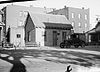 | September 29, 1970 (#70000635) | Corner of Polk and Washington Sts. 48°06′50″N 122°45′35″W / 48.1139°N 122.7597°W / 48.1139; -122.7597 (Capt. Enoch S. Fowler House) | Port Townsend | Is on the Washington Trust for Historic Preservation's Most Endangered Historic Properties List.[8] |
| 19 | Gagen-Sherlock House | 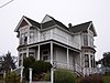 | March 19, 1982 (#82004220) | 1906 Cherry St. 48°07′47″N 122°46′05″W / 48.1297°N 122.7681°W / 48.1297; -122.7681 (Gagen-Sherlock House) | Port Townsend | |
| 20 | Galster House | 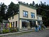 | July 14, 1983 (#83003325) | Water St. 48°02′02″N 122°45′54″W / 48.0339°N 122.765°W / 48.0339; -122.765 (Galster House) | Lower Hadlock | |
| 21 | Graves Creek Ranger Station |  | July 13, 2007 (#07000717) | Approximately 22 miles (35 km) northeast of WA 101 on Quinault River Rd. 47°34′09″N 123°34′40″W / 47.5691°N 123.5778°W / 47.5691; -123.5778 (Graves Creek Ranger Station) | Port Angeles | |
| 22 | J. W. Griffiths House | 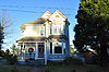 | May 16, 1985 (#85001103) | 2030 Monroe St. 48°07′34″N 122°45′43″W / 48.126001°N 122.761832°W / 48.126001; -122.761832 (J. W. Griffiths House) | Port Townsend | |
| 23 | Hamilton-Worthington House | 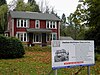 | October 8, 2014 (#14000849) | 101 E. Columbia St. 47°49′40″N 122°52′33″W / 47.8279°N 122.8759°W / 47.8279; -122.8759 (Hamilton-Worthington House) | Quilcene | |
| 24 | Happy Four Shelter |  | July 13, 2007 (#07000719) | Approximately 5.4 along Hoh River Trail 47°52′06″N 123°49′41″W / 47.868333°N 123.828056°W / 47.868333; -123.828056 (Happy Four Shelter) | Port Angeles | |
| 25 | F. C. Harper House |  | May 16, 1985 (#85001104) | 502 Reed St. 48°07′34″N 122°45′45″W / 48.126083°N 122.762548°W / 48.126083; -122.762548 (F. C. Harper House) | Port Townsend | |
| 26 | Hayes River Fire Cache | Upload image | July 13, 2007 (#07000738) | Approximately 16.8 miles (27.0 km) up the Elwha River Trail 47°48′34″N 123°27′09″W / 47.809444°N 123.4525°W / 47.809444; -123.4525 (Hayes River Fire Cache) | Port Angeles | |
| 27 | House at 1723 Holcomb Street |  | May 16, 1985 (#85001105) | 1723 Holcomb St. 48°06′46″N 122°47′07″W / 48.112778°N 122.785278°W / 48.112778; -122.785278 (House at 1723 Holcomb Street) | Port Townsend | |
| 28 | House at 30 Tremont Street |  | May 16, 1985 (#85001106) | 30 Tremont St. 48°07′34″N 122°45′32″W / 48.126111°N 122.758889°W / 48.126111; -122.758889 (House at 30 Tremont Street) | Port Townsend | |
| 29 | House at 503 Fir Street |  | May 16, 1985 (#85001107) | 503 Fir St. 48°07′11″N 122°47′42″W / 48.119722°N 122.795°W / 48.119722; -122.795 (House at 503 Fir Street) | Port Townsend | |
| 30 | Interrorem Guard Station — Olympic National Forest |  | July 17, 2013 (#13000506) | Duckabush Road 47°40′43″N 122°59′34″W / 47.6786°N 122.9927°W / 47.6786; -122.9927 (Interrorem Guard Station — Olympic National Forest) | Duckabush vicinity | |
| 31 | Irondale Historic District |  | July 14, 1983 (#83003326) | Port Townsend Bay and Admirally Inlet 48°02′33″N 122°45′58″W / 48.0425°N 122.7661°W / 48.0425; -122.7661 (Irondale Historic District) | Port Townsend | |
| 32 | Irondale Jail |  | July 14, 1983 (#83003327) | Moore St. 48°02′42″N 122°46′04″W / 48.045°N 122.7678°W / 48.045; -122.7678 (Irondale Jail) | Irondale | |
| 33 | Francis Wilcox James House |  | September 29, 1970 (#70000636) | Corner of Washington and Harrison Sts. 48°06′49″N 122°45′40″W / 48.1137°N 122.7611°W / 48.1137; -122.7611 (Francis Wilcox James House) | Port Townsend | |
| 34 | Jefferson County Courthouse |  | April 24, 1973 (#73001871) | Jefferson and Case Sts. 48°06′44″N 122°46′03″W / 48.1122°N 122.7676°W / 48.1122; -122.7676 (Jefferson County Courthouse) | Port Townsend | |
| 35 | Johnson House | 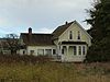 | July 14, 1983 (#83003328) | 287 Flagler Rd. 48°02′58″N 122°41′17″W / 48.0494°N 122.6881°W / 48.0494; -122.6881 (Johnson House) | Nordland | |
| 36 | Kuhn Spit Archeological Site |  | December 22, 1978 (#78002747) | Address restricted[9] | Chimacum | |
| 37 | Lake-Little House | 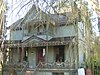 | May 16, 1985 (#85001108) | 1607 Sheridan St. 48°06′43″N 122°47′23″W / 48.1119°N 122.7897°W / 48.1119; -122.7897 (Lake-Little House) | Port Townsend | |
| 38 | Colonel Henry Landes House | 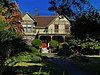 | June 28, 2021 (#100006702) | 1034 Franklin St. 48°06′57″N 122°45′37″W / 48.1157°N 122.7602°W / 48.1157; -122.7602 (Colonel Henry Landes House) | Port Townsend | |
| 39 | J. N. Laubach House |  | May 16, 1985 (#85001109) | 613 F St. 48°07′14″N 122°46′05″W / 48.1206°N 122.7681°W / 48.1206; -122.7681 (J. N. Laubach House) | Port Townsend | |
| 40 | Leader Building |  | September 29, 1970 (#70000637) | 226 Adams St. 48°06′55″N 122°45′15″W / 48.1153°N 122.7542°W / 48.1153; -122.7542 (Leader Building) | Port Townsend | Also known as the Fowler Building. |
| 41 | Lincoln School | 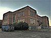 | September 8, 2017 (#100001596) | 450 Fir St. 48°07′08″N 122°46′09″W / 48.1189°N 122.7693°W / 48.1189; -122.7693 (Lincoln School) | Port Townsend | |
| 42 | Manresa Hall | 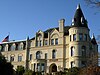 | September 29, 1970 (#70000638) | Sheridan St. 48°06′17″N 122°47′20″W / 48.104722°N 122.788889°W / 48.104722; -122.788889 (Manresa Hall) | Port Townsend | Also known as Eisenbeis Castle and Manresa Inn. |
| 43 | Methodist Episcopal Church of Port Hadlock |  | July 14, 1983 (#83003329) | Randolph and Curtiss Sts. 48°02′03″N 122°46′09″W / 48.034167°N 122.769167°W / 48.034167; -122.769167 (Methodist Episcopal Church of Port Hadlock) | Hadlock | |
| 44 | O. L. and Josephine Morgan House |  | May 16, 1985 (#85001110) | 1033 Pierce St. 48°07′03″N 122°46′00″W / 48.1175°N 122.766667°W / 48.1175; -122.766667 (O. L. and Josephine Morgan House) | Port Townsend | |
| 45 | Nelson House |  | October 10, 1984 (#84000101) | Freeman Rd. 48°02′06″N 122°41′34″W / 48.035°N 122.692778°W / 48.035; -122.692778 (Nelson House) | Nordland | |
| 46 | North Fork Quinault Ranger Station |  | July 13, 2007 (#07000718) | Approximately 18 miles (29 km) northeast of WA 101 on N. Fork Rd. off N. Shore Quinault Rd. 47°34′26″N 123°38′50″W / 47.573831°N 123.647149°W / 47.573831; -123.647149 (North Fork Quinault Ranger Station) | Port Angeles | |
| 47 | Earl Oatman House |  | July 14, 1983 (#83003330) | Muncie St. 47°49′03″N 122°44′22″W / 47.8175°N 122.739444°W / 47.8175; -122.739444 (Earl Oatman House) | Quilcene | |
| 48 | Old German Consulate | 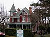 | February 24, 1971 (#71000869) | 313 Walker St. 48°06′39″N 122°46′03″W / 48.110916°N 122.767422°W / 48.110916; -122.767422 (Old German Consulate) | Port Townsend | |
| 49 | Olympus Guard Station | Upload image | November 5, 2007 (#07000722) | Approximately 9 miles (14 km) from Hoh River Trailhead at Hoh Ranger Station 47°52′35″N 123°45′52″W / 47.87648°N 123.764426°W / 47.87648; -123.764426 (Olympus Guard Station) | Port Angeles | |
| 50 | Pearson House |  | May 16, 1985 (#85001111) | 1939 27th St. 48°07′09″N 122°47′26″W / 48.119167°N 122.790556°W / 48.119167; -122.790556 (Pearson House) | Port Townsend | |
| 51 | Pelton Creek Shelter | Upload image | July 13, 2007 (#07000727) | Approximately 15.5 miles (24.9 km) up the Queets River Trail 47°42′09″N 123°45′48″W / 47.7025°N 123.763333°W / 47.7025; -123.763333 (Pelton Creek Shelter) | Port Angeles | |
| 52 | H. S. Petersen House |  | May 16, 1985 (#85001112) | 50th and Kuhn St. 48°08′10″N 122°46′49″W / 48.136111°N 122.780278°W / 48.136111; -122.780278 (H. S. Petersen House) | Port Townsend | |
| 53 | Benjamin S. Pettygrove House | 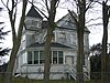 | September 25, 1985 (#85002662) | 1000 G St. 48°07′20″N 122°46′19″W / 48.122222°N 122.771944°W / 48.122222; -122.771944 (Benjamin S. Pettygrove House) | Port Townsend | Also known as the Pettygrove House. |
| 54 | Point Wilson Lighthouse | 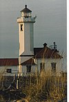 | March 24, 1971 (#71000870) | On a point of land between Juan de Fuca Strait and Admiralty Inlet 48°08′39″N 122°45′14″W / 48.144167°N 122.753889°W / 48.144167; -122.753889 (Point Wilson Lighthouse) | Port Townsend | |
| 55 | Port Townsend Carnegie Library |  | August 3, 1982 (#82004908) | 1220 Lawrence 48°07′00″N 122°45′44″W / 48.116667°N 122.762222°W / 48.116667; -122.762222 (Port Townsend Carnegie Library) | Port Townsend | Carnegie Libraries of Washington TR |
| 56 | Port Townsend Historic District |  | May 17, 1976 (#76001883) | Roughly bounded by Scott, Blaine, Walker, and Taft Sts., and the Waterfront 48°07′01″N 122°45′39″W / 48.116944°N 122.760833°W / 48.116944; -122.760833 (Port Townsend Historic District) | Port Townsend | |
| 57 | Quilcene-Quinault Battleground Site | Upload image | December 29, 1978 (#78002748) | Address restricted[9] | Quilcene | |
| 58 | Quilcene Ranger Station |  | March 27, 2012 (#12000162) | 61 Herbert St. 47°49′23″N 122°52′37″W / 47.823134°N 122.876932°W / 47.823134; -122.876932 (Quilcene Ranger Station) | Quilcene | |
| 59 | Judge Ralston House |  | May 16, 1985 (#85001113) | 1523 Madison St. 48°07′27″N 122°45′43″W / 48.12411°N 122.761928°W / 48.12411; -122.761928 (Judge Ralston House) | Port Townsend | |
| 60 | Rothschild House |  | September 29, 1970 (#70000639) | Taylor and Franklin Sts. 48°06′58″N 122°45′23″W / 48.116111°N 122.756389°W / 48.116111; -122.756389 (Rothschild House) | Port Townsend | Built in 1868, this is Port Townsend's oldest house. |
| 61 | Hanna Rover House |  | July 14, 1983 (#83003331) | Chimacum-Center Rd. 47°58′23″N 122°46′11″W / 47.973056°N 122.769722°W / 47.973056; -122.769722 (Hanna Rover House) | Center | |
| 62 | Saint's Rest, Tukey's Pioneer Cabin and Homestead House |  | July 14, 1983 (#83003332) | Chevy Chase Rd. 48°03′11″N 122°50′34″W / 48.053056°N 122.842778°W / 48.053056; -122.842778 (Saint's Rest, Tukey's Pioneer Cabin and Homestead House) | Port Townsend | |
| 63 | James C. Saunders House |  | October 18, 1977 (#77001335) | Sims Way 48°06′13″N 122°47′11″W / 48.103611°N 122.786389°W / 48.103611; -122.786389 (James C. Saunders House) | Port Townsend | |
| 64 | Ferdinand Schlager House |  | May 16, 1985 (#85001114) | 810 Rose St. 48°07′20″N 122°46′09″W / 48.122222°N 122.769167°W / 48.122222; -122.769167 (Ferdinand Schlager House) | Port Townsend | |
| 65 | Seal Rock Shell Mounds (45JE15) |  | June 12, 1985 (#85001247) | Address restricted[9] | Brinnon | |
| 66 | Capt. Peter Shibles House |  | July 14, 1983 (#83003333) | Curtiss St. 48°02′04″N 122°46′01″W / 48.034444°N 122.766944°W / 48.034444; -122.766944 (Capt. Peter Shibles House) | Hadlock | |
| 67 | Tollef Sole House |  | July 14, 1983 (#83003334) | 275 Flagler Rd. 48°02′55″N 122°41′29″W / 48.048611°N 122.691389°W / 48.048611; -122.691389 (Tollef Sole House) | Nordland | |
| 68 | St. Paul's Episcopal Church |  | September 29, 1970 (#70000640) | Corner of Jefferson and Tyler Sts. 48°06′56″N 122°45′28″W / 48.115556°N 122.757778°W / 48.115556; -122.757778 (St. Paul's Episcopal Church) | Port Townsend | |
| 69 | Starrett House |  | September 29, 1970 (#70000641) | 744 Clay St. 48°07′05″N 122°45′25″W / 48.118056°N 122.756944°W / 48.118056; -122.756944 (Starrett House) | Port Townsend | |
| 70 | Andrew Stegerwald House |  | May 16, 1985 (#85001115) | 1710 Fir St. 48°07′40″N 122°46′00″W / 48.127859°N 122.766792°W / 48.127859; -122.766792 (Andrew Stegerwald House) | Port Townsend | |
| 71 | Hans Swanson House | 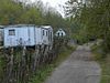 | July 14, 1983 (#83003335) | Swansonville Rd. 47°56′20″N 122°42′15″W / 47.938889°N 122.704167°W / 47.938889; -122.704167 (Hans Swanson House) | Port Ludlow | |
| 72 | Tamanowas Rock |  | August 3, 2015 (#15000498) | Address restricted[9] | Chimacum vicinity | |
| 73 | John Trumbull House |  | May 16, 1985 (#85001116) | 925 Wilson St. 48°06′26″N 122°47′15″W / 48.107222°N 122.7875°W / 48.107222; -122.7875 (John Trumbull House) | Port Townsend | |
| 74 | Horace Tucker House | 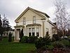 | January 18, 1973 (#73001872) | 706 Franklin St. 48°07′03″N 122°45′20″W / 48.1175°N 122.755556°W / 48.1175; -122.755556 (Horace Tucker House) | Port Townsend | |
| 75 | Uncas School | 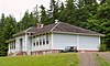 | February 5, 1987 (#87000025) | E. Uncas Rd. 47°59′01″N 122°53′00″W / 47.983532°N 122.883416°W / 47.983532; -122.883416 (Uncas School) | Discovery Bay | |
| 76 | U.S. Post Office – Port Townsend Main |  | May 30, 1991 (#91000652) | 1322 Washington 48°06′48″N 122°45′43″W / 48.11344°N 122.761993°W / 48.11344; -122.761993 (U.S. Post Office – Port Townsend Main) | Port Townsend | |
| 77 | Van Trojen House |  | October 10, 1984 (#84000100) | Van Trojen Rd. 47°59′43″N 122°48′38″W / 47.995278°N 122.810556°W / 47.995278; -122.810556 (Van Trojen House) | Chimacum | |
| 78 | Milo P. Ward House | 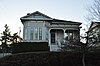 | May 16, 1985 (#85001117) | 1707 Jackson St. 48°07′33″N 122°45′40″W / 48.125839°N 122.761135°W / 48.125839; -122.761135 (Milo P. Ward House) | Port Townsend | |
| 79 | F/V Western Flyer (purse seiner) | 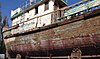 | May 8, 2017 (#100000990) | 919 Haines Pl. 48°06′24″N 122°46′52″W / 48.106553°N 122.780990°W / 48.106553; -122.780990 (F/V Western Flyer (purse seiner)) | Port Townsend | |
| 80 | Hattie Williams House | 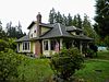 | July 14, 1983 (#83003336) | Moore St. 48°02′07″N 122°46′30″W / 48.035278°N 122.775°W / 48.035278; -122.775 (Hattie Williams House) | Irondale |
Former listings
| [5] | Name on the Register | Image | Date listed | Date removed | Location | City or town | Description |
|---|---|---|---|---|---|---|---|
| 1 | Chow Chow Bridge |  | July 16, 1982 (#82004218) | April 25, 1988 | Spans Quinault River | Taholah |
See also
- National Register of Historic Places listings in Washington state
- Listings in neighboring counties: Clallam, Grays Harbor, Island, Kitsap, Mason
- List of National Historic Landmarks in Washington (state)
- Historic preservation
- History of Washington (state)
- Index of Washington (state)-related articles
References
- ^ Andrus, Patrick W.; Shrimpton, Rebecca H.; et al. (2002). "How to Apply the National Register Criteria for Evaluation". National Register Bulletin. National Park Service, U.S. Department of the Interior. Retrieved June 20, 2014.
- ^ National Park Service. "National Register of Historic Places Program: Research". Retrieved January 28, 2015.
- ^ Department of Archaeology and Historic Preservation. "Washington Information System for Architectural and Archaeological Records Data (WISAARD)". Retrieved February 14, 2015.
- ^ National Park Service, United States Department of the Interior, "National Register of Historic Places: Weekly List Actions", retrieved June 28, 2024.
- ^ a b Numbers represent an alphabetical ordering by significant words. Various colorings, defined here, differentiate National Historic Landmarks and historic districts from other NRHP buildings, structures, sites or objects.
- ^ "National Register Information System". National Register of Historic Places. National Park Service. April 24, 2008.
- ^ The eight-digit number below each date is the number assigned to each location in the National Register Information System database, which can be viewed by clicking the number.
- ^ Most Endangered Properties :: The Washington Trust for Historic Preservation
- ^ a b c d Federal and state laws and practices restrict general public access to information regarding the specific location of this resource. In some cases, this is to protect archeological sites from vandalism, while in other cases it is restricted at the request of the owner. See: Knoerl, John; Miller, Diane; Shrimpton, Rebecca H. (1990), Guidelines for Restricting Information about Historic and Prehistoric Resources, National Register Bulletin, National Park Service, U.S. Department of the Interior, OCLC 20706997.
External links
Map all coordinates using OpenStreetMap
Download coordinates as:
- KML
- GPX (all coordinates)
- GPX (primary coordinates)
- GPX (secondary coordinates)
- Washington Department of Archaeology and Historic Preservation, Historic Register program
- National Park Service, National Register of Historic Places site
 Media related to National Register of Historic Places in Jefferson County, Washington at Wikimedia Commons
- v
- t
- e
National Register of Historic Places listings in Washington (state)
by county
- Adams
- Asotin
- Benton
- Chelan
- Clallam
- Clark
- Columbia
- Cowlitz
- Douglas
- Ferry
- Franklin
- Garfield
- Grant
- Grays Harbor
- Island
- Jefferson
- King
- Kitsap
- Kittitas
- Lewis
- Lincoln
- Mason
- Okanogan
- Pacific
- Pend Oreille
- Pierce
- San Juan
- Skagit
- Skamania
- Snohomish
- Spokane
- Stevens
- Thurston
- Wahkiakum
- Walla Walla
- Whatcom
- Whitman
- Yakima

- National Historic Landmarks
- Bridges and Tunnels
| |
|---|---|
| Topics | |
| Lists by state |
|
| Lists by insular areas | |
| Lists by associated state | |
| Other areas | |
| Related | |
| |


Municipalities and communities of Jefferson County, Washington, United States | ||
|---|---|---|
County seat: Port Townsend | ||
| City | 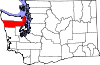 | |
| CDPs | ||
| Other communities | ||
| Indian reservation | ||
| Ghost towns |
| |
| Footnotes | ‡This populated place also has portions in an adjacent county or counties | |
| ||


