National Register of Historic Places listings in Stevens County, Washington

This list presents the full set of buildings, structures, objects, sites, or districts designated on the National Register of Historic Places in Stevens County, Washington, and offers brief descriptive information about each of them. The National Register recognizes places of national, state, or local historic significance across the United States.[1] Out of over 90,000 National Register sites nationwide,[2] Washington is home to approximately 1,500,[3] and 25 of those are found partially or wholly in Stevens County.
This National Park Service list is complete through NPS recent listings posted June 28, 2024.[4]
Current listings
| [5] | Name on the Register | Image | Date listed[6] | Location | City or town | Description |
|---|---|---|---|---|---|---|
| 1 | Barstow Bridge | Upload image | March 30, 1995 (#95000263) | US 395 and Co. Rd. 4061 over the Kettle River 48°47′05″N 118°07′32″W / 48.784623°N 118.125475°W / 48.784623; -118.125475 (Barstow Bridge) | Kettle Falls | Bridges of Washington State MPS, also extends into Ferry County. Removed and replaced in 2010. |
| 2 | Clayton School |  | August 28, 2003 (#03000862) | Corner of Park Ave. and Swenson Rd. 47°59′45″N 117°33′57″W / 47.995848°N 117.565955°W / 47.995848; -117.565955 (Clayton School) | Clayton | Rural Public Schools of Washington State MPS |
| 3 | Collins Building | 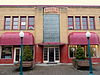 | November 19, 1998 (#98001418) | 202 S. Main St. 48°32′36″N 117°54′23″W / 48.543332°N 117.906275°W / 48.543332; -117.906275 (Collins Building) | Colville | |
| 4 | Columbia River Bridge at Kettle Falls | 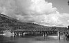 | March 28, 1995 (#95000260) | US 395 over the Columbia River 48°37′34″N 118°07′01″W / 48.626111°N 118.116944°W / 48.626111; -118.116944 (Columbia River Bridge at Kettle Falls) | Kettle Falls | Bridges of Washington State MPS, also extends into Ferry County |
| 5 | Columbia River Bridge at Northport | 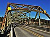 | May 24, 1995 (#95000624) | WA 25 over the Columbia R. 48°55′21″N 117°46′32″W / 48.9225°N 117.775556°W / 48.9225; -117.775556 (Columbia River Bridge at Northport) | Northport | Bridges of Washington State MPS |
| 6 | Colville Flour Mill | 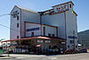 | June 29, 1995 (#95000809) | 466 W. First St. 48°32′39″N 117°54′40″W / 48.544167°N 117.911111°W / 48.544167; -117.911111 (Colville Flour Mill) | Colville | |
| 7 | Hudsons Bay Gristmill Site on Colville River | 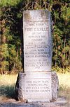 | April 12, 1982 (#82004295) | Address Restricted | Kettle Falls | |
| 8 | Keller House |  | April 18, 1979 (#79002559) | 700 N. Wynne St. 48°33′05″N 117°54′25″W / 48.551389°N 117.906944°W / 48.551389; -117.906944 (Keller House) | Colville | |
| 9 | Kettle Falls District | Upload image | November 20, 1974 (#74000352) | Address Restricted | Kettle Falls | |
| 10 | Little Falls Hydroelectric Power Plant | 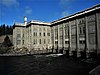 | December 15, 1988 (#88002737) | Spokane River 47°49′53″N 117°55′00″W / 47.831389°N 117.916667°W / 47.831389; -117.916667 (Little Falls Hydroelectric Power Plant) | Reardan | |
| 11 | Long Lake Hydroelectric Power Plant | 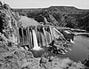 | December 15, 1988 (#88002738) | Spokane River 47°50′10″N 117°50′19″W / 47.836111°N 117.838611°W / 47.836111; -117.838611 (Long Lake Hydroelectric Power Plant) | Ford | |
| 12 | Long Lake Pictographs | Upload image | May 24, 1976 (#76001922) | Address Restricted | Ford | |
| 13 | Loon Lake School |  | November 19, 1992 (#92001592) | 4000 Colville Rd. 48°03′48″N 117°37′54″W / 48.063243°N 117.631557°W / 48.063243; -117.631557 (Loon Lake School) | Loon Lake | Rural Public Schools of Washington State MPS |
| 14 | H. M. McCauley House | Upload image | April 18, 1979 (#79002560) | 285 Oak St. 48°32′42″N 117°54′13″W / 48.545°N 117.903611°W / 48.545; -117.903611 (H. M. McCauley House) | Colville | |
| 15 | Meyers Falls Power Plant Historic District | 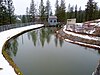 | June 29, 1995 (#95000808) | 0.5 mi. S of Kettle Falls at Colville R., on either side of Juniper St. 48°35′42″N 118°03′36″W / 48.594961°N 118.059996°W / 48.594961; -118.059996 (Meyers Falls Power Plant Historic District) | Kettle Falls | |
| 16 | Northport School | 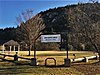 | October 4, 1979 (#79002561) | South and 7th Sts. 48°54′49″N 117°46′59″W / 48.913611°N 117.783056°W / 48.913611; -117.783056 (Northport School) | Northport | |
| 17 | Old Indian Agency |  | May 17, 1974 (#74001981) | 309 N. 3rd St. E. 48°16′44″N 117°42′50″W / 48.278829°N 117.713834°W / 48.278829; -117.713834 (Old Indian Agency) | Chewelah | |
| 18 | Opera House and IOOF Lodge |  | April 18, 1997 (#97000319) | 151 W. 1st Ave. 48°32′40″N 117°54′18″W / 48.544444°N 117.905°W / 48.544444; -117.905 (Opera House and IOOF Lodge) | Colville | |
| 19 | Orient Bridge | 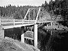 | July 16, 1982 (#82004297) | Richardson Rd., Spans Kettle River 48°51′59″N 118°11′52″W / 48.866389°N 118.197778°W / 48.866389; -118.197778 (Orient Bridge) | Orient | Historic Bridges and Tunnels in Washington TR, also extends into Ferry County |
| 20 | Red Mountain Railroad Bridge | Upload image | July 16, 1982 (#82004296) | Spans Little Sheep Creek 48°58′03″N 117°48′53″W / 48.9675°N 117.814722°W / 48.9675; -117.814722 (Red Mountain Railroad Bridge) | Northport | Historic Bridges and Tunnels in Washington TR |
| 21 | Rickey Block | 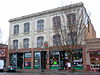 | June 30, 1995 (#95000807) | 230 S. Main St. 48°32′35″N 117°54′22″W / 48.542976°N 117.906204°W / 48.542976; -117.906204 (Rickey Block) | Colville | |
| 22 | St. Paul's Mission |  | November 20, 1974 (#74002259) | West of Kettle Falls on Lake Roosevelt 48°37′37″N 118°06′18″W / 48.626944°N 118.105°W / 48.626944; -118.105 (St. Paul's Mission) | Kettle Falls | |
| 23 | Spokane River Bridge at Long Lake Dam |  | May 24, 1995 (#95000628) | WA 231 over the Spokane R. 47°50′19″N 117°51′05″W / 47.838611°N 117.851389°W / 47.838611; -117.851389 (Spokane River Bridge at Long Lake Dam) | Reardan | extends into Lincoln County, Washington |
| 24 | U.S. Post Office – Colville Main | 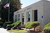 | August 7, 1991 (#91000644) | 204 S. Oak 48°32′35″N 117°54′13″W / 48.543056°N 117.903611°W / 48.543056; -117.903611 (U.S. Post Office – Colville Main) | Colville | |
| 25 | Colburn T. Winslow House | 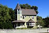 | April 26, 1990 (#90000670) | 458 E. 2nd St. 48°32′43″N 117°53′57″W / 48.545278°N 117.899167°W / 48.545278; -117.899167 (Colburn T. Winslow House) | Colville |
Former listings
| [5] | Name on the Register | Image | Date listed | Date removed | Location | City or town | Description |
|---|---|---|---|---|---|---|---|
| 1 | Winslow Railroad Bridge | Upload image | July 16, 1982 (#82004298) | December 15, 1999 | S of Colville | Colville | Destroyed by fire on August 27, 1999. |
See also
- National Register of Historic Places listings in Washington state
- Listings in neighboring counties: Ferry, Lincoln, Pend Oreille, Spokane
- Historic preservation
- History of Washington (state)
- Index of Washington (state)-related articles
References
- ^ Andrus, Patrick W.; Shrimpton, Rebecca H.; et al. (2002). "How to Apply the National Register Criteria for Evaluation". National Register Bulletin. National Park Service, U.S. Department of the Interior. Retrieved June 20, 2014.
- ^ National Park Service. "National Register of Historic Places Program: Research". Retrieved January 28, 2015.
- ^ Department of Archaeology and Historic Preservation. "Washington Information System for Architectural and Archaeological Records Data (WISAARD)". Retrieved February 14, 2015.
- ^ National Park Service, United States Department of the Interior, "National Register of Historic Places: Weekly List Actions", retrieved June 28, 2024.
- ^ a b Numbers represent an alphabetical ordering by significant words. Various colorings, defined here, differentiate National Historic Landmarks and historic districts from other NRHP buildings, structures, sites or objects.
- ^ The eight-digit number below each date is the number assigned to each location in the National Register Information System database, which can be viewed by clicking the number.
External links
Map all coordinates using OpenStreetMap
Download coordinates as:
- KML
- GPX (all coordinates)
- GPX (primary coordinates)
- GPX (secondary coordinates)
- Washington Department of Archaeology and Historic Preservation, Historic Register program
- National Park Service, National Register of Historic Places site
 Media related to National Register of Historic Places in Stevens County, Washington at Wikimedia Commons
- v
- t
- e
National Register of Historic Places listings in Washington (state)
by county
- Adams
- Asotin
- Benton
- Chelan
- Clallam
- Clark
- Columbia
- Cowlitz
- Douglas
- Ferry
- Franklin
- Garfield
- Grant
- Grays Harbor
- Island
- Jefferson
- King
- Kitsap
- Kittitas
- Lewis
- Lincoln
- Mason
- Okanogan
- Pacific
- Pend Oreille
- Pierce
- San Juan
- Skagit
- Skamania
- Snohomish
- Spokane
- Stevens
- Thurston
- Wahkiakum
- Walla Walla
- Whatcom
- Whitman
- Yakima

- National Historic Landmarks
- Bridges and Tunnels
| |
|---|---|
| Topics | |
| Lists by state |
|
| Lists by insular areas | |
| Lists by associated state | |
| Other areas | |
| Related | |
| |


Municipalities and communities of Stevens County, Washington, United States | ||
|---|---|---|
County seat: Colville | ||
| Cities |  | |
| Towns | ||
| CDPs | ||
| Other communities | ||
| Ghost towns |
| |
| ||


