National Register of Historic Places listings in Weld County, Colorado
List of National Register of Historic Places in Weld County, Colorado, United States
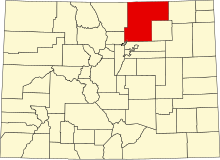
This is a list of the National Register of Historic Places listings in Weld County, Colorado.
This is intended to be a complete list of the properties and districts on the National Register of Historic Places in Weld County, Colorado, United States. The locations of National Register properties and districts for which the latitude and longitude coordinates are included below, may be seen in a map.[1]
There are 41 properties and districts listed on the National Register in the county, and one formerly listed property.
This National Park Service list is complete through NPS recent listings posted June 7, 2024.[2]
- v
- t
- e
Properties on the National Register of Historic Places in Colorado by county
- Adams
- Alamosa
- Arapahoe
- Archuleta
- Baca
- Bent
- Boulder
- Broomfield
- Chaffee
- Cheyenne
- Clear Creek
- Conejos
- Costilla
- Crowley
- Custer
- Delta
- Denver
- Dolores
- Douglas
- Eagle
- El Paso
- Elbert
- Fremont
- Garfield
- Gilpin
- Grand
- Gunnison
- Hinsdale
- Huerfano
- Jackson
- Jefferson
- Kiowa
- Kit Carson
- La Plata
- Lake
- Larimer
- Las Animas
- Lincoln
- Logan
- Mesa
- Mineral
- Moffat
- Montezuma
- Montrose
- Morgan
- Otero
- Ouray
- Park
- Phillips
- Pitkin
- Prowers
- Pueblo
- Rio Blanco
- Rio Grande
- Routt
- Saguache
- San Juan
- San Miguel
- Sedgwick
- Summit
- Teller
- Washington
- Weld
- Yuma

Map all coordinates using OpenStreetMap
Download coordinates as:
- KML
- GPX (all coordinates)
- GPX (primary coordinates)
- GPX (secondary coordinates)
Current listings
| [3] | Name on the Register[4] | Image | Date listed[5] | Location | City or town | Description |
|---|---|---|---|---|---|---|
| 1 | Amanda K. Alger Memorial Methodist Episcopal Church |  | October 25, 2006 (#06000949) | 303 Maple Ave. 40°31′45″N 104°42′49″W / 40.529167°N 104.713611°W / 40.529167; -104.713611 (Amanda K. Alger Memorial Methodist Episcopal Church) | Eaton | |
| 2 | Anderson Barn |  | October 6, 2004 (#04001112) | 5255 State Highway 60 40°20′11″N 104°57′20″W / 40.33646°N 104.95552°W / 40.33646; -104.95552 (Anderson Barn) | Johnstown | Barn built in 1913 of individually formed ornamental blocks. |
| 3 | Artesia Farm | Upload image | March 22, 2018 (#100002223) | 11820 Cty. Rd. 64 1/2 40°27′29″N 104°49′56″W / 40.457974°N 104.832239°W / 40.457974; -104.832239 (Artesia Farm) | Greeley vicinity | |
| 4 | Clubhouse-Student Union |  | October 29, 2008 (#08001021) | Between 18th and 19th Sts., and 8th and 10th Aves. 40°20′11″N 104°57′18″W / 40.336389°N 104.955°W / 40.336389; -104.955 (Clubhouse-Student Union) | Greeley | Now called Gray Hall. It houses police and parking departments of the University of Northern Colorado. |
| 5 | Elmer and Etta Ball Ranch |  | October 16, 1991 (#91001533) | County Road 69 west of Briggsdale 40°37′26″N 104°24′45″W / 40.623889°N 104.4125°W / 40.623889; -104.4125 (Elmer and Etta Ball Ranch) | Briggsdale | |
| 6 | Jared L. Brush Barn |  | October 16, 1991 (#91001532) | 24308 County Road 17 40°21′09″N 104°54′13″W / 40.35247°N 104.90352°W / 40.35247; -104.90352 (Jared L. Brush Barn) | Johnstown | Hay barn built by reformed gold miner and homesteader Jared Lamar Brush in 1865. |
| 7 | Daniels School | 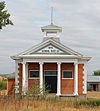 | July 6, 2005 (#05000653) | State Highway 60 and County Road 25 40°19′50″N 104°49′30″W / 40.33050°N 104.82490°W / 40.33050; -104.82490 (Daniels School) | Milliken | One-room schoolhouse built in 1911 in Classical Revival style. |
| 8 | Dearfield |  | August 4, 1995 (#95001002) | Along US 34, 11 miles west of Wiggins 40°17′18″N 104°15′25″W / 40.288333°N 104.256944°W / 40.288333; -104.256944 (Dearfield) | Wiggins | |
| 9 | Aaron James Eaton House |  | April 19, 2006 (#06000281) | 207 Elm St. 40°31′40″N 104°42′44″W / 40.527778°N 104.712222°W / 40.527778; -104.712222 (Aaron James Eaton House) | Eaton | |
| 10 | First Baptist Church |  | November 25, 1987 (#87001510) | Northwestern corner of the intersection of 10th Ave. and 11th St. 40°25′18″N 104°41′39″W / 40.421667°N 104.694167°W / 40.421667; -104.694167 (First Baptist Church) | Greeley | |
| 11 | First Methodist Episcopal Church |  | July 7, 2004 (#04000660) | 503 Walnut St. 40°28′42″N 104°54′14″W / 40.478333°N 104.903889°W / 40.478333; -104.903889 (First Methodist Episcopal Church) | Windsor | |
| 12 | Fort Vasquez |  | September 30, 1970 (#70000169) | 13412 U.S. Highway 85 40°11′40″N 104°49′13″W / 40.194444°N 104.820278°W / 40.194444; -104.820278 (Fort Vasquez) | Platteville | |
| 13 | Glazier House | 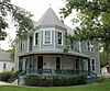 | February 5, 1991 (#91000002) | 1403 10th Ave. 40°25′00″N 104°41′39″W / 40.416667°N 104.694167°W / 40.416667; -104.694167 (Glazier House) | Greeley | |
| 14 | Greeley Downtown | 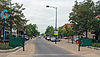 | July 24, 2008 (#08000707) | Roughly bounded by 8th St., 8th Ave., 10th St., and 9th Ave. 40°25′26″N 104°41′30″W / 40.423902°N 104.691737°W / 40.423902; -104.691737 (Greeley Downtown) | Greeley | |
| 15 | Greeley High School |  | April 15, 1999 (#99000444) | 1515 14th Ave. 40°24′53″N 104°42′07″W / 40.414722°N 104.701944°W / 40.414722; -104.701944 (Greeley High School) | Greeley | |
| 16 | Greeley High School and Grade School |  | July 23, 1981 (#81000189) | 1015 8th St. 40°25′31″N 104°41′43″W / 40.425278°N 104.695278°W / 40.425278; -104.695278 (Greeley High School and Grade School) | Greeley | |
| 17 | Greeley Junior High School |  | October 11, 2003 (#03001012) | 811 15th St. 40°24′58″N 104°41′27″W / 40.416111°N 104.690833°W / 40.416111; -104.690833 (Greeley Junior High School) | Greeley | |
| 18 | Greeley Masonic Temple |  | July 7, 2004 (#04000663) | 829 10th Ave. 40°25′27″N 104°41′39″W / 40.424167°N 104.694167°W / 40.424167; -104.694167 (Greeley Masonic Temple) | Greeley | |
| 19 | Greeley Tribune Building |  | April 18, 2007 (#07000310) | 714 8th St. 40°25′29″N 104°41′22″W / 40.424722°N 104.689444°W / 40.424722; -104.689444 (Greeley Tribune Building) | Greeley | |
| 20 | Greeley Union Pacific Railroad Depot |  | November 4, 1993 (#93001180) | Junction of 7th Ave. and 9th St. 40°25′27″N 104°41′17″W / 40.424167°N 104.688056°W / 40.424167; -104.688056 (Greeley Union Pacific Railroad Depot) | Greeley | |
| 21 | Jurgens Site | Upload image | July 18, 1990 (#90001084) | 1 mile (1.6 km) north of Kersey on State Highway 37[6] 40°24′27″N 104°33′56″W / 40.407500°N 104.565556°W / 40.407500; -104.565556 (Jurgens Site) | Kersey | |
| 22 | Keota Stone Circles Archeological District | Upload image | July 28, 1981 (#81000190) | Address Restricted | Keota | |
| 23 | Land Utilization Program Headquarters |  | October 29, 2009 (#09000854) | 44741 County Road 77 40°39′01″N 104°20′05″W / 40.650258°N 104.334608°W / 40.650258; -104.334608 (Land Utilization Program Headquarters) | Briggsdale | |
| 24 | Lincoln School |  | July 22, 1981 (#81000188) | 645 Holbrook St. 40°03′03″N 105°03′00″W / 40.05072°N 105.04988°W / 40.05072; -105.04988 (Lincoln School) | Erie | School in service from 1906 to 1966, now the Erie Town Hall. |
| 25 | Little Thompson River Bridge |  | October 15, 2002 (#02001129) | Interstate 25 service road at milepost 249.90 40°18′04″N 104°58′47″W / 40.30110°N 104.97978°W / 40.30110; -104.97978 (Little Thompson River Bridge) | Berthoud | Camelback pony truss bridge built in 1938. |
| 26 | Meeker Memorial Museum |  | February 26, 1970 (#70000168) | 1324 9th Ave. 40°25′02″N 104°41′29″W / 40.417222°N 104.691389°W / 40.417222; -104.691389 (Meeker Memorial Museum) | Greeley | |
| 27 | Milne Farm |  | February 3, 1993 (#92001840) | 18457 State Highway 392 40°28′53″N 104°42′23″W / 40.481389°N 104.706389°W / 40.481389; -104.706389 (Milne Farm) | Lucerne | |
| 28 | Nettleton-Mead House |  | April 2, 2002 (#02000290) | 1303 9th Ave. 40°25′06″N 104°41′32″W / 40.418333°N 104.692222°W / 40.418333; -104.692222 (Nettleton-Mead House) | Greeley | |
| 29 | Ottesen Grain Company Feed Mill |  | November 5, 1998 (#98001320) | 815 7th St. 40°05′10″N 104°48′30″W / 40.086111°N 104.808333°W / 40.086111; -104.808333 (Ottesen Grain Company Feed Mill) | Fort Lupton | |
| 30 | Harvey J. Parish House |  | April 14, 2000 (#00000368) | 701 Charlotte St. 40°20′10″N 104°54′49″W / 40.336111°N 104.913611°W / 40.336111; -104.913611 (Harvey J. Parish House) | Johnstown | |
| 31 | Sandstone Ranch |  | January 23, 1984 (#84000904) | East of Longmont off State Highway 119 40°09′05″N 105°02′12″W / 40.151389°N 105.036667°W / 40.151389; -105.036667 (Sandstone Ranch) | Longmont | |
| 32 | SLW Ranch | 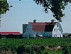 | March 15, 1991 (#91000288) | 27401 County Road 58½ 40°24′53″N 104°29′34″W / 40.414722°N 104.492778°W / 40.414722; -104.492778 (SLW Ranch) | Kersey vicinity | |
| 33 | Star Filling Station |  | November 15, 2019 (#100004614) | 301 Centre Ave. 40°36′28″N 103°50′43″W / 40.6079°N 103.8452°W / 40.6079; -103.8452 (Star Filling Station) | New Raymer | |
| 34 | United Church of Christ of Highlandlake | 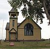 | February 10, 1989 (#88002237) | 16896 County Road 5 40°14′55″N 105°00′50″W / 40.248611°N 105.013889°W / 40.248611; -105.013889 (United Church of Christ of Highlandlake) | Mead | |
| 35 | Von Gohren-Thompson Homestead-Gerry Farm Rural Historic Landscape | Upload image | May 4, 2011 (#11000240) | Address Restricted | Greeley | Historic Farms and Ranches of Weld County MPS |
| 36 | Von Trotha-Firestien Farm at Bracewell | 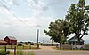 | May 12, 2009 (#09000291) | Junction of O St. and 83rd Ave., in Bracewell[7] 40°27′32″N 104°49′00″W / 40.458889°N 104.816667°W / 40.458889; -104.816667 (Von Trotha-Firestien Farm at Bracewell) | Bracewell vicinity | |
| 37 | Weld County Courthouse |  | January 9, 1978 (#78000886) | 9th St. and 9th Ave. 40°25′25″N 104°41′35″W / 40.42351°N 104.69319°W / 40.42351; -104.69319 (Weld County Courthouse) | Greeley | Classical Revival courthouse designed by William N. Bowman and completed in 1917. One of Colorado's most substantial county courthouses. |
| 38 | West Stoneham Archeological District | Upload image | September 23, 1994 (#94001115) | Address Restricted | Stoneham | |
| 39 | White-Plumb Farm |  | July 27, 2005 (#05000729) | 955 39th Ave. 40°25′21″N 104°44′42″W / 40.4225°N 104.745°W / 40.4225; -104.745 (White-Plumb Farm) | Greeley | Now called the Plumb Farm Learning Center and owned by the City of Greeley. |
| 40 | Windsor Town Hall |  | January 15, 1999 (#98001599) | 116 5th St. 40°28′50″N 104°54′13″W / 40.480556°N 104.903611°W / 40.480556; -104.903611 (Windsor Town Hall) | Windsor | |
| 41 | Joseph A. Woodbury House |  | May 17, 1984 (#84000908) | 1124 7th St. 40°25′32″N 104°41′48″W / 40.425556°N 104.696667°W / 40.425556; -104.696667 (Joseph A. Woodbury House) | Greeley |
Former listings
| [3] | Name on the Register | Image | Date listed | Date removed | Location | City or town | Description |
|---|---|---|---|---|---|---|---|
| 1 | Windsor Milling and Elevator Co. Building |  | September 3, 1998 (#98001129) | March 12, 2018 | 301 Main St. 40°28′47″N 104°54′01″W / 40.479722°N 104.900278°W / 40.479722; -104.900278 (Windsor Milling and Elevator Co. Building) | Windsor | Destroyed by fire in August, 2017[8] |
See also
 History portal
 United States portal
 Colorado portal
 National Register of Historic Places portal


- List of National Historic Landmarks in Colorado
- List of National Register of Historic Places in Colorado
- Bibliography of Colorado
- Geography of Colorado
- History of Colorado
- Index of Colorado-related articles
- List of Colorado-related lists
- Outline of Colorado
References
- ^ The latitude and longitude information provided in this table was derived originally from the National Register Information System, which has been found to be fairly accurate for about 99% of listings. Some locations in this table may have been corrected to current GPS standards.
- ^ National Park Service, United States Department of the Interior, "National Register of Historic Places: Weekly List Actions", retrieved June 7, 2024.
- ^ a b Numbers represent an alphabetical ordering by significant words. Various colorings, defined here, differentiate National Historic Landmarks and historic districts from other NRHP buildings, structures, sites or objects.
- ^ "National Register Information System". National Register of Historic Places. National Park Service. July 9, 2010.
- ^ The eight-digit number below each date is the number assigned to each location in the National Register Information System database, which can be viewed by clicking the number.
- ^ Wheat, Joe Ben, and Linda Scott. "Memoir 15: The Jurgens Site". Plains Anthropologist 24.84 Whole Number (1979): 8.
- ^ Location derived from this Greeley Tribune article; the NRIS lists the site as "Address Restricted"
- ^ "Windsor Mill".
External links
Wikimedia Commons has media related to Weld County, Colorado.
- State of Colorado
- History Colorado
- Weld County, Colorado
| |
|---|---|
| Topics | |
| Lists by state |
|
| Lists by insular areas | |
| Lists by associated state | |
| Other areas | |
| Related | |
| |


Municipalities and communities of Weld County, Colorado, United States | ||
|---|---|---|
County seat: Greeley | ||
| Cities |  | |
| Towns | ||
| CDPs | ||
| Unincorporated communities | ||
| Ghost towns | ||
| Trading posts |
| |
| Footnotes | ‡This populated place also has portions in an adjacent county or counties | |
| ||
| |
|---|---|
Denver (capital) | |
| Topics |
|
| Society | |
| Cities |
|
| Counties |
|
| Regions |
|
 Colorado portal Colorado portal | |
| |||||||||||||||||||||||||||||||||
|---|---|---|---|---|---|---|---|---|---|---|---|---|---|---|---|---|---|---|---|---|---|---|---|---|---|---|---|---|---|---|---|---|---|
| Federal |
| ||||||||||||||||||||||||||||||||
| State |
| ||||||||||||||||||||||||||||||||
| Trails |
| ||||||||||||||||||||||||||||||||
40°33′15″N 104°23′38″W / 40.5542°N 104.3938°W / 40.5542; -104.3938 (Weld County, Colorado)


